username
X
password
register
for free!
help
  This is likely a great time to hike this trail!  Check out "Preferred" months below, keep in mind this is an estimate.
 

River House Ruins, UT

Guide 3 Triplogs  0 Topics
  4 of 5  
Fav
Wish
0
details
drive
no permit
forecast
route  
stats
photos
triplogs
topics
location
24 3 0
HAZ reminds you to respect the ruins. Please read the Archaeological Resources Protection Act of 1979 & Ruins Etiquette
Statistics
tap row or icons for details
Difficulty 1 of 5
Route Finding 1 of 5
Distance Round Trip 0.5 miles
Trailhead Elevation 4,280 feet
Elevation Gain 180 feet
Avg Time Round Trip 30 min
Kokopelli Seeds 1.4
 Interest Ruins
 Backpack Possible - Not Popular
feature photo
Photos Viewed All MineFollowing
Inaugural Calculation on Button Tap!
12  2019-05-13 Steph_and_Blake
12  2019-02-14 Stoic
14  2018-04-20
San Juan River Hikes - Mile 0 to Mile 27
AZLOT69
Author
author avatar Guides 100
Routes 63
Photos 2,548
Trips 184 map ( 820 miles )
Age 76 Male Gender
Location Grand Junction, CO
Associated Areas
list map done
Southeast Region
Historical Weather
Trailhead Forecast
Radar Map
Expand Map
Preferred Sep, Dec, Mar, Jun
Seasons   Early Autumn to Early Summer
Sun  5:52am - 6:42pm
Official Route & 2 Rts
 
0 Alternative


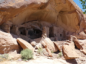
gentle stairs await your arrival
by Steph_and_Blake

  Likely In-Season!
Overview
A well-preserved two story cliff dwelling (also known as the Snake House) with both petroglyphs and pictographs overlooking the San Juan river.


Note
If you're able to drive all the way to the ruin, this isn't so much of a hike as it is walking up the steps, checking out the ruins and rock art, and traversing west along the sandstone bench to see granaries and more rock art. If you don't have a high-clearance vehicle, park in Comb Wash and hike east for one mile to reach the site.
remove free decal offer
Hike
Ascend the gentle stairs to reach the dwellings. While being careful not to touch the walls, notice the T-shaped doorways, intact wood beams, and plaster work. After examining the buildings, locate the pictographs on the back wall, particularly the large snake. Continue to the left along a wide ledge to find granaries tucked into the cliff and some finely detailed petroglyphs. Looking down from the cliff there are some mounded areas that might have once been surface dwellings. A nearby ammo can offers information on the site.

2019-05-17 Steph_and_Blake


    Check out the Official Route and Triplogs.
    Leave No Trace and +Add a Triplog after your hike to support this local community.
    WARNING! Hiking and outdoor related sports can be dangerous. Be responsible and prepare for the trip. Study the area you are entering and plan accordingly. Dress for the current and unexpected weather changes. Take plenty of water. Never go alone. Make an itinerary with your plan(s), route(s), destination(s) and expected return time. Give your itinerary to trusted family and/or friends.

     Permit $$
    None


     Directions
    or
     Road
    Strictly 4x4

    To hike
    From Bluff, Utah, drive west on Highway 163 for 7 miles. Once through the Comb and headed down-hill, take the first left onto Comb Wash. Note that this dirt road can be quite muddy, has some sections of deep sand, and crosses the stream numerous times. Near the river, after about 4 miles on Comb Wash, there's a sharp left turn up a rocky hill. A high-clearance, 4x4 vehicle is required to make it up this hill. Once up the hill follow the dirt road, headed east, to the large parking area for the ruins.
    page created by Stoic on May 17 2019 9:00 am
     90+° 8am - 6pm kills
    helpcorrectionissue

    end of page marker