|
tap row or icons for details
|
| Difficulty |
|
2 of 5 |
| Route Finding |
|
2 of 5 |
| Distance Round Trip |
|
1.5 miles |
| Trailhead Elevation |
|
5,019 feet |
| Elevation Gain |
|
85 feet |
| Accumulated Gain |
|
150 feet |
| Avg Time Round Trip |
|
2 hours |
| Kokopelli Seeds |
|
2.25 |
| Interest Ruins, Historic & Perennial Creek | | Backpack Possible - Not Popular | | unreported if dogs are allowed
editedit > ops > dogs to adjust |
| | |
|
|
6 |
2019-05-12 | Steph_and_Blake |
|
|
8 |
2019-05-07 | AZLOT69 |
|
| |
|
|
|
list |
map |
done |
Southeast Region |
| | |
|
| |
|
|
Historical Weather |
| Trailhead Forecast | | |
|
 |
|
|
| Preferred May, Jun, Sep, Oct → 9 AM |
| |
|
|
| | |
| |
Named Locations Coordinate Links
| |
|
| help future hikers |
| post a gps route now |
| | |
| |
|
|
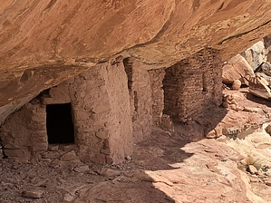
 Don't judge a book by its cover. There's a lot going on at this location for the curious. Rather short and not too difficult but full of surprises. Your adventure starts at the north end of this parking area. Cross the creek and follow the old ATV trail to the point it ends. Looking to the right there are several ruins on the ledge about thirty feet of the ground. Slow down and use your soft eyes to take it all in watching for rock art. Moving to your left you can make your way up to the thirty foot ledge. Now you can examine these ruins up close and look for petroglyphs. Once you've had your fill here look directly across at the rock peninsula. Work your way over to it and notice the unusual geology along the way. Move to your left going around the left side and into the adjoining canyon. You'll find at least four more sets of ruins over here as well as some unique pictographs and petroglyphs. Look up as you traverse the ledge or you will miss things twenty feet above you. When finished return the way you came. |
 Route Editor