|
tap row or icons for details
|
| Difficulty |
|
1 of 5 |
| Route Finding |
|
1 of 5 |
| Distance Round Trip |
|
1 mile |
| Trailhead Elevation |
|
6,412 feet |
| Elevation Gain |
|
44 feet |
| Accumulated Gain |
|
120 feet |
| Avg Time Round Trip |
|
1 hour |
| Kokopelli Seeds |
|
1.6 |
| Interest Off-Trail Hiking, Ruins & Historic | | Backpack No | | unreported if dogs are allowed
editedit > ops > dogs to adjust |
| | |
|
|
|
list |
map |
done |
Central Region |
| | |
|
| |
|
|
Historical Weather |
| Trailhead Forecast | | |
|
 |
|
|
| Preferred May, Jun, Sep, Oct → 10 AM |
| |
|
|
| | |
| |
Named Locations Coordinate Links
| |
|
| help future hikers |
| post a gps route now |
| | |
| |
|
|
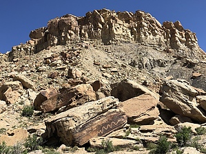
 Make this as easy or hard as you want. From the paved parking lot you can clearly see some rock art on the varnish covered boulders strewn all around from the molen reef. From casual observation to detailed examination of all sides of the boulders your sure to find ancient rock art as well as interesting inscriptions. Most impressive are the huge snake petroglyphs, one over seven feet long. A couple other highlights included a very detailed lizard, and an inscription from the CCC 1939. When your appetite for rock art has been satisfied look for some dinosaur tracks. You'll find them if you hike east from the parking lot and stay to the left of the old road bed. They span across a large flat topped sandstone boulder. There's no sign to point you to it but if you have ever been to an interpretive dinosaur site you will recognize them. They are quite impressive if you are into that kind of thing. When finished return the way you came. |
 Route Editor