Route Editor

| Guide | ♦ | 1 Triplog | 0 Topics |
details | drive | no permit | forecast | map |
stats |
photos | triplog | topics | location |
| 14 | 1 | 0 |
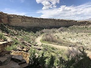
A Horseshoe Called A Box by AZLOT69 Do not attempt this if wet or threat of rain. Roads are impassable when wet. There is a maze of roads in the area. A GPS route would be a good idea to run a track. Hike From the log fence work your way north along the cliff looking for a way down to the creek. In about a quarter mile there is a crack that makes for a fairly easy descent. There is usually a few cairns here. Once at the bottom you can pick up a trail headed south and toward the base of the cliff face. In about one hundred yards you'll see a snake pictogram at eye level. Continuing on you'll arrive at the Rainbow Panel which is far above you, look high. You may have to back up towards the creek for a good shot. Binoculars and or a zoom camera would be a plus. There is also a nice panel next to the Rainbow of humanoids.
When you have had your fill return the way you came. Check out the Triplog. Leave No Trace and +Add a Triplog after your hike to support this local community. | |||||||||||||||||||||||||||||||||||||||||||||||||||||||||||||||||||||||||||||||||||||||||