 Route Editor

| Guide | ♦ | 28 Triplogs | 0 Topics |
details | drive | no permit | forecast | route |
stats |
photos | triplogs | topics | location |
| 157 | 28 | 0 |
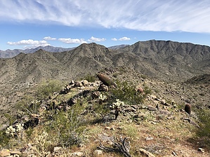
 Overview OverviewShort side trail leading from Pyrite Trail to the summit at the far western edge of Skyline Regional Park. Getting there From the main parking area, head north across the bridge then left on Mountain Wash Trail for 0.20 miles. Turn left on Turnbuckle Trail for 0.40 miles. Then left on Granite Falls Trail for 0.80 miles. Then Left on Pyrite Trail for 1.70 miles up to the turn for Pyrite Summit. All junctions are signed. Distance from the parking area to the start of Pyrite Summit trail is about 3.30 miles and 785' aeg.
Once you turn onto Pyrite Summit trail, you will head west-southwest up a smooth trail to the summit, gaining just under 200' in about a third of a mile. This may be the most scenic of the four summits in the park, and due to its distance from the trailhead, probably the least visited. Open views to the west, and on a clear day, you can see many of the desert mountain ranges in western AZ. Once done, retrace your steps to Pyrite Trail. You can return to the trailhead the way you came, or for a longer loop, can head north on Pyrite trail and take one of the numerous connecting trails back. Make sure you have enough water for what could easily become a 10-mile loop if you take this option.
Check out the Official Route and Triplogs. Leave No Trace and +Add a Triplog after your hike to support this local community. One-Way Notice This hike is listed as One-Way. When hiking several trails on a single "hike", log it with a generic name that describes the hike. Then link the trails traveled, check out the example. | |||||||||||||||||||||||||||||||||||||||||||||||||||||||||||||||||||||||||||||||||||||||||||||||||||||||||||||||||||||||||||||||||||||||||||||||||||||||||||||||||||||||||||||||||||||||||


