 Route Editor

| Guide | ♦ | 3 Triplogs | 1 Topic |
details | drive | no permit | forecast | 🔥 route |
stats |
photos | triplogs | topic | location |
| 38 | 3 | 1 |
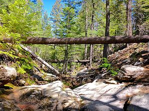
No Chocolates by kingsnake   Box Canyon is the named canyon that splits the plateau/ridge formed by General Springs Canyon and Fred Haught Canyon. Box Canyon is the named canyon that splits the plateau/ridge formed by General Springs Canyon and Fred Haught Canyon.It's 2.5 miles from FR 95 to General Springs Canyon, with the middle 50% being the box canyon that gives it its name. The box contains two good-sized pours which are best negotiated to either side due to overhangs. The second is particularly verdant and most likely to be flowing. The remainder of the box has the usual array of deadfall that must be clambered over or limboed under. Grab & stabs are sparse.
The bottom quarter, emptying into General Springs Canyon is a narrow cienega where, even if flowing, the creek may be easily crossed dry. After canyon crawling Box Canyon, the attached route returns to the trailhead via FR 395. You can do a longer loop, ~7.5 miles, by continuing along General Springs Canyon, then taking Fred Haught Canyon back to the trailhead. (Fred Haught is shallow the whole way and has no major obstacles.) Check out the Official Route and Triplogs. Leave No Trace and +Add a Triplog after your hike to support this local community. One-Way Notice This hike is listed as One-Way. When hiking several trails on a single "hike", log it with a generic name that describes the hike. Then link the trails traveled, check out the example. | ||||||||||||||||||||||||||||||||||||||||||||||||||||||||||||||||||||||||||||||||||||||||||


