Route Editor

| Guide | ♦ | 2 Triplogs | 0 Topics |
details | drive | no permit | forecast | map |
stats |
photos | triplogs | topics | location |
| 11 | 2 | 0 |
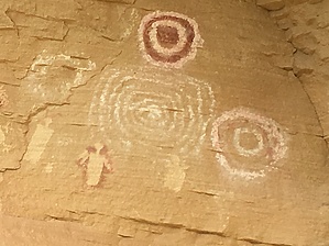
Kokopelli Handshake by Steph_and_Blake  The Canyon Pintado ("Painted Canyon") National Historic District is located along a 15-mile stretch of Highway 139 south of Rangely, Colorado. Hundreds of archaeological sites are found in Canyon Pintado, primarily deriving from Fremont and Ute occupation of the Douglas Creek canyon. Seven of these sites are set up for public viewing with interpretive signs and information. History Canyon Pintado got its name from Fathers Dominguez and Escalante when they traveled through the area in 1776.
This Guide is not meant to be an exhaustive description of the seven sites included in this driving/hiking "tour", but rather an attempt to give the reader a sense of what to expect. We visited Waving Hands, Kokopelli, and East Four Mile and found the rock art well-preserved and interesting. Hike The sites are all signed and are generally located right beside Highway 139. Parking, although limited, is available. The hikes are brief (except for East Four Mile) with little-to-no elevation gain. In some cases, you don't even need to leave your car to view the rock art. Rangely Area Chamber of Commerce Lists the Canyon Pintado sites (as well as other sites to the west), a description of what you'll see by mile-marker and an overview map. BLM Division Details Canyon Pintado National Historic District encompasses over 16,000 acres of public land along 15 miles of State Highway 139. Canyon Pintado (Spanish for "Painted Canyon") received its name in 1776 when Fathers Dominguez and Escalante noted numerous examples of ancient Native American rock art as they traveled through the Douglas Creek Valley. For more information, please contact the White River Field Office. See also Quicklinks @ BLM Check out the Triplogs. Leave No Trace and +Add a Triplog after your hike to support this local community. | |||||||||||||||||||||||||||||||||||||||||||||||||||||||||||||||||||||||||||||||||||