Route Editor

| Guide | ♦ | 1 Triplog | 0 Topics |
details | drive | permit | forecast | map |
stats |
photos | triplog | topics | location |
| 9 | 1 | 0 |
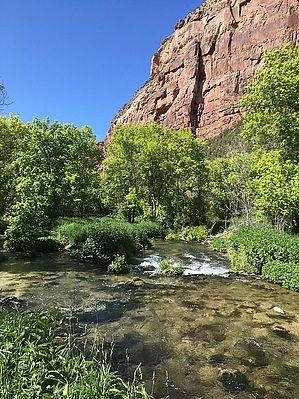
permit required for 30 days in the hole by Steph_and_Blake  Although not often seen, this is black bear and mountain lion territory. There are also two short stretches of poison ivy along the trail. Overview Jones Hole Trail is a beautiful, scenic hike along a babbling stream for a high desert area, through lush vegetation, past some rock art, and to the junction with the Green River. Bonus - opportunity to see some bighorn sheep up close.
John Wesley Powell gave Jones Hole its name during his 1871 expedition down the Green River. He named the area in honor of the expedition's photographer, Stephen Vandiver Jones. Local lore, however, says that the full name (Jones Hole) came into being in 1883 when a Charley Jones hid in the area for an entire winter after believing he had killed another man. Upon learning that the other man had lived, supposedly, Charley yelled: "You mean I can finally get out of this hole?!" Hike The hike begins at the parking lot next to the Jones Hole Fish Hatchery (which is interesting in and of itself). The trail hugs the fence on the hatchery's east side before entering the wooded area along the stream. At this point, the stream will be on your right as you follow the mostly packed dirt trail. You may encounter an occasional angler attempting to land a trout or someone cooling off in the water. Be on the lookout for bighorn sheep. The ones we encountered behaved as if we weren't even there. About 1 3/4 miles into the hike, you'll cross the stream on a well-built bridge. Shortly after the bridge, pay attention to off-shoots from the main trail. This is where you'll find the bold, red pictographs. After pondering the meaning of the rock art, rejoin the main course and continue southward towards the Green River. The scenery along the way changes from significant shade from the canopy of trees, to small meadows, to soaring sandstone walls, to a tranquil stream dotted with areas of mini-whitewater. After 4 miles, you'll lose sight of the stream and head a little southwest to reach the Green. Follow the signs for the "Day Use Area" to get to the beach. The river is green-ish (at least compared to the Colorado River), and it would be fun to watch rafters float by. There's shade in spots, and you can find some downed trees to serve as a chair of sorts for a snack break. Return the way you came. Water Sources I believe there was a sign indicating that you should not drink water in the stream, but we didn't pay attention as to why. It was crystal clear, and I don't know why you couldn't filter/treat the water. But, to be on the safe side, take all you'll need. Camping There is one camping spot right off the trail where Ely Creek joins Jones Hole, and there's also a camping spot along the Green River. Both require backcountry permits. Note We rated the difficulty of this hike a 2.5 only for the length. The elevation gain/loss is barely noticeable over the 4-mile length. Check out the Triplog. Leave No Trace and +Add a Triplog after your hike to support this local community. | ||||||||||||||||||||||||||||||||||||||||||||||||||||||||||||||||||||||||||||||||||||||