 Route Editor

| Guide | ♦ | 1 Triplog | 0 Topics |
details | drive | no permit | forecast | route |
stats |
photos | triplog | topics | location |
| 14 | 1 | 0 |
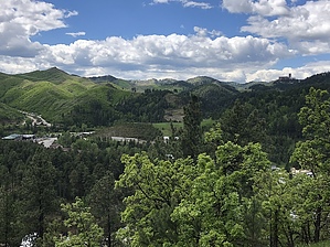
Stake Your Claim by AZLOT69 Deadwood and Lead South Dakota were founded in or about the same time of 1876. Gold was the catalyst and it created a rush of people west. Some of the most notorious characters were Wyatt Earp, Calamity Jane and Wild Bill Hickok. Transportation was poor and supplies to both communities was at a premium. The first railroad to the region arrived in 1890. With the advent of cars and trucks the railroad was eventually abandoned in 1928. In 2017 the cities banded together to turn the old railroad grade into a recreational trail. Hike Starting at the Deadwood trailhead it's basically uphill all the way to Lead. Some suggestions would be to set up a key exchange, prearrange a shuttle, or do an out and back. Starting at the George Mickelson trailhead proceed in a southwest direction for about a quarter mile. There's a sitting bench on the right and a trail takes off to the right here doing a 180 and heads up hill. The trail starts and ends in an urban area so the only solitude is in the middle section of trail. The trade off is the beautiful views of both towns and surrounding countryside from the ridgeline the trail follows. Keep your eyes open for artifacts and or evidence of the Gold Rush Days. There are several off shoots from the main trail but it was well marked at these points as off this writing. The trail concludes at the Lead Open Cut. When it closed in 2002 it was the largest and deepest gold mine in North America. Check out the Official Route and Triplog. Leave No Trace and +Add a Triplog after your hike to support this local community. One-Way Notice This hike is listed as One-Way. When hiking several trails on a single "hike", log it with a generic name that describes the hike. Then link the trails traveled, check out the example. | ||||||||||||||||||||||||||||||||||||||||||||||||||||||||||||||||||||||||||||||||||||||||


