 Route Editor

| Guide | ♦ | 1 Triplog | 0 Topics |
details | drive | no permit | forecast | route |
stats |
photos | triplog | topics | location |
| 15 | 1 | 0 |
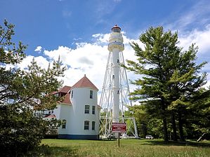
Born on a Bayou by kingsnake IATA Point Beach Segment Info
Neshotah Park to Viceroy Rd. If you park in Neshotah Park, rather than at the end of Park Rd., it is a half mile walk on pavement to the end of Park Rd. (The Lake Michigan shore north of Neshotah Park is no trespassing private property for several hundred yards.) 200 yds. from the end of Park Rd., split right onto a boardwalk towards Lake Michigan. Then follow the trailless shoreline two miles north. I found the best footing to be at the water's edge, where the sand was moist (not wet) & firm. At 0.5 miles, there is a creek crossing. Depending on tide, you may be able to jump across it, or have to wade through the calf-deep water. At 2.0 miles, there is a MUCH larger creek, marked by a bench & sign. Turn inland across a boardwalk. After entering the tree line, the next mile or so winds along the bayou of Molash Creek. 200 yds. before Viceroy Rd. the trail turns to wide gravel bike path. 100 yds. before the road, the official Ice Age Trail route turns right, also along wide gravel path, across a large wooden bridge. Viceroy Rd. to Red Pine Lot Roadside parking on Viceroy Rd. is legal according to the IATA. In 100 yards, turn left, crossing the large wooden bridge over Molash Creek. In 0.4 miles, at the Swiggum Bench, split right off the wide gravel path onto the dirt single track, which basically follows the north bank of Molash Creek, opposite the first sub-segment. At 1.3 miles, the Ice Age Trail bypasses Coenen Cabin and Fetchbaw Cabin. The adjacent cabins both have picnic tables, fire rings, his & her pit toilets, etc. At least Fetchbaw has a well pump. At 1.5 miles, the trail crosses the gravel cabin access road. At 1.8 miles, the trail does a brief ⅓ mile inland loop before continuing to follow Lake Michigan from just inside the tree line. Once across Molash Creek, there are numerous small trails to access the shoreline, and it is legal to hike along it, all the way to Rawley Point Lighthouse, if you prefer to surf to shade. At 2.5 miles, where the trail again turns inland, there are two official wild camping sites known as Kayak Camp. Each has a fire ring, and one has single seat pit toilet with two trailside walls and no roof. The next ¾ mile to Rawley Point access road winds between more bayous. Upon reaching the road, either turn right towards the lighthouse, or left for a final ¼ mile to the Red Pine Lot on the opposite side of County Highway O. Rawley Point Lighthouse Current vehicle access is $8 for WI plates; $11 for out-of-state plates, but unlike Red Pine Lot, there are toilets and water. The impressive truss-supported lighthouse is tall, and narrow. The lighthouse nearby grounds are unfenced, but no trespassing. From the Ice Age Trail to Lake Michigan & back is only a ½ mile. Red Pine Lot to Lake Shore Rd. Now roughly a ⅓ mile away from Lake Michigan, the sounds of waves are replaced by traffic on County Highway O. (Though the traffic is much lighter than the Piestewa Freeway!) Being slightly further inland, the first two miles to County Highway V were the driest of the Point Beach Segment. At 1.3 miles, there is a "stay on trail" sign, as the Ice Age Trail is crossing private land. North of County V, at least, that land belongs to Manitowoc Public Schools, and is dotted with Eagle Scout projects. At 2.3 miles, there is a ⅓ mile long, wetlands-protecting, boardwalk across a beautiful swamp. From the west end of the boardwalk, it is only another ⅓ of a mile to Lake Shore Rd., with legal roadside parking.
Check out the Official Route and Triplog. Leave No Trace and +Add a Triplog after your hike to support this local community. One-Way Notice This hike is listed as One-Way. When hiking several trails on a single "hike", log it with a generic name that describes the hike. Then link the trails traveled, check out the example. | ||||||||||||||||||||||||||||||||||||||||||||||||||||||||||||||||||||||||||||||||||


