username
X
password
register
for free!
help


Custer Skywalk, SD

Guide 1 Triplog  0 Topics
  2 of 5  
Fav
Wish
0
details
drive
no permit
forecast
map
stats
photos
triplog
topics
location
7 1 0
Statistics
tap row or icons for details
Distance Round Trip 1 mile
Trailhead Elevation 5,312 feet
Elevation Gain 400 feet
Accumulated Gain 465 feet
Kokopelli Seeds 3.33
 Interest Peak
feature photo
Photos Viewed All MineFollowing
7  2019-06-25 AZLOT69
Author
author avatar Guides 595
Routes 0
Photos 0
Trips 247 map ( 429 miles )
Age ?
Location
Associated Areas
list map done
Western Region
Historical Weather
Trailhead Forecast
Expand Map
Preferred May, Jun, Jul, Aug
Sun  6:21am - 7:25pm
0 Route
 
0 Alternative


remove free decal offer

 
Guide Needed
Publish Full Detail Guide


Use +Add above to share photos and triplogs
A straight forward hike up to an observation platform. There are 313 steps. Great views of the southern Black Hills.

Happy

Trails!


    Check out the Triplog.
    Leave No Trace and +Add a Triplog after your hike to support this local community.
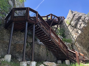
    WARNING! Hiking and outdoor related sports can be dangerous. Be responsible and prepare for the trip. Study the area you are entering and plan accordingly. Dress for the current and unexpected weather changes. Take plenty of water. Never go alone. Make an itinerary with your plan(s), route(s), destination(s) and expected return time. Give your itinerary to trusted family and/or friends.

     Permit $$
    None


     Directions
    or
     Road
    Paved - Car Okay

    To hike
    From downtown Custer take 6th street south to French Creek Rd. Park here at Harbach Centennial Park. This is your Trailhead.
    page created by AZLOT69 on Jun 25 2019 4:02 pm
     90+° 8am - 6pm kills
    helpcorrectionissue

    end of page marker