Route Editor

| Guide | ♦ | 5 Triplogs | 0 Topics |
details | drive | no permit | forecast | route |
stats |
photos | triplogs | topics | location |
| 59 | 5 | 0 |
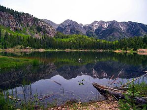
Hike: From the informal and often crowded trailhead, adjacent to lily pad covered Scout Lake, the Spud Lake Trail #661 departs from a trail sign into an attractive mix of aspens, columbines, and wildflowers, following the route of an old road. While gradually ascending, the old road narrows into a footpath, and the hike crosses an open hillside where one can get a nice view to the west of the 12,000 foot, barren rock summits of Grayrock Peak and Engineer Mountain, from a rocky viewpoint near the trail.
Nearing its end, the trail proceeds through a low pass, and arrives at Potato Lake, situated in a shallow, forested bowl, at the base of 11,871 foot Potato Hill. The trail ends here, although one can circumnavigate the lake along a well used footpath to enjoy a changing view of this beautiful area. Check out the Official Route and Triplogs. Leave No Trace and +Add a Triplog after your hike to support this local community. | |||||||||||||||||||||||||||||||||||||||||||||||||||||||||||||||||||||||||||||||||||||||||||