username
X
password
register
for free!
help
 

Titcomb Basin, WY

Guide 4 Triplogs  0 Topics
  5 of 5  
Fav
Wish
1
details
drive
no permit
forecast
route  
stats
photos
triplogs
topics
location
47 4 0
Statistics
tap row or icons for details
Distance One Way 16 miles
Trailhead Elevation 9,361 feet
Elevation Gain 1,288 feet
Accumulated Gain 2,876 feet
Kokopelli Seeds 25.58
 Interest Perennial Waterfall & Perennial Creek
feature photo
Photos Viewed All MineFollowing
49  2021-09-01
Wind River - Island Lake - Titcomb Basin
BiFrost
17  2020-09-03 ShatteredArm
15  2020-07-10
Island Lake
FOTG
15  2019-07-07 FOTG
Author
author avatar Guides 595
Routes 0
Photos 0
Trips 247 map ( 429 miles )
Age ?
Location
Associated Areas
list map done
Central Region
Historical Weather
Trailhead Forecast
Radar Map
Expand Map
Preferred Aug, Aug, Aug, Aug
Sun  5:48am - 6:47pm
Official Route & 1 Rt
 
0 Alternative


remove free decal offer

Overview
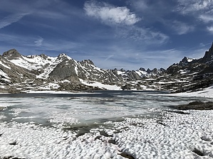
Titcomb Basin is undoubtedly the jewel of the Wind River Range and perhaps the jewel of the Rocky Mountains, or the northern Rockies at the very least. The area is heavily visited by climbers and backpackers alike for this reason. The Wind River Range receives heavy snowfall during the winter and for this reason Titcomb Basin remains snowed in until late July nearly every year.


The Hike
Titcomb Basin is a premier backpacking and climbing destination that can be reached via a combination of several different trails and trailheads. However, the Pole Creek Trail out of the Elkhart Park Trailhead is the most popular choice and offers the most direct and perhaps easiest access to the basin.


    Check out the Official Route and Triplogs.
    Leave No Trace and +Add a Triplog after your hike to support this local community.

    One-Way Notice
    This hike is listed as One-Way.

    When hiking several trails on a single "hike", log it with a generic name that describes the hike. Then link the trails traveled, check out the example.
    WARNING! Hiking and outdoor related sports can be dangerous. Be responsible and prepare for the trip. Study the area you are entering and plan accordingly. Dress for the current and unexpected weather changes. Take plenty of water. Never go alone. Make an itinerary with your plan(s), route(s), destination(s) and expected return time. Give your itinerary to trusted family and/or friends.

     Permit $$
    None


     Directions
    or
     Road
    Paved - Car Okay

    To hike
    The Elkhart Park Trailhead is located about 15 miles northeast of Pinedale Wyoming.
    page created by FOTG on Jul 14 2019 8:05 pm
     90+° 8am - 6pm kills
    helpcorrectionissue

    end of page marker