Route Editor

| Guide | ♦ | 1 Triplog | 0 Topics |
details | drive | no permit | forecast | map |
stats |
photos | triplog | topics | location |
| 19 | 1 | 0 |
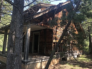
A Black Hills Bust by AZLOT69 Gold was discovered here in 1890. It continued to function until 1940 but its best year was 1927. There were a few attempts to start it up again but the town was completely abandoned by 1985. Several structures are scattered over a large town site among the thick forest and grass. Little gold was found here. The miners located lessor minerals such as silver, mica, and zinc. Hike About a quarter mile in from the gate is the first structure, perhaps a schoolhouse. Follow the established footpaths thru the heavy grass for other highlights. As you work your way over to the concrete Powder House the trail will go to the right and past an old Mill site.
Continue and you will come to more established trail. Take it to the right and you will find a lone grave. An apparent misunderstanding over a mining claim. A little further along you will find the Superintendent's house. Explore to your heart's content then turn around and just past the Supers house take the trail to the right. It will take you by a bunkhouse ( ? ) and complete your loop back where you started by the Powder House. Gate Policy: If a gate is closed upon arrival, leave it closed after you go through. If it is open, leave it open. Leaving a closed gate open may put cattle in danger. Closing an open gate may cut them off from water. Please be respectful, leave gates as found. The exception is signage on the gate directing you otherwise. Check out the Triplog. Leave No Trace and +Add a Triplog after your hike to support this local community. | |||||||||||||||||||||||||||||||||||||||||||||||||||||||||||||||||||||||||||||||||||||||