Route Editor

| Guide | ♦ | 3 Triplogs | 0 Topics |
details | drive | no permit | forecast | route |
stats |
photos | triplogs | topics | location |
| 23 | 3 | 0 |
Warning: As with any hike above treeline, be sure to start early to avoid thunderstorms.
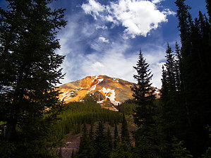
Hike: From Highway 550, San Juan County Road #14 almost immediately turns south, near the site of the Koehler Tunnel. This is the best place to park, as the road soon crosses onto private property. Hike south along the road, which begins to turn east to climb a steep, forested ravine. Near the top of the ravine, the road forks. Go left, through another gate. The route passes the ruins of the historic Carbon Lake Mine, as it snakes it way up a small basin. On the upper edge of the basin, the road reaches a fork, next to a collapsed log structure. Stay left. Just above the basin, the route bypasses a locked gate in the road, and suddenly finds itself above treeline, with a view of Red Mountain number 3's summit. The road continues east and upward, across tundra slopes, reaching a saddle at 12,100 feet. Views are outstanding, with an endless sea of high peaks to the east and west. Leaving the saddle for its summit push, the road steepens considerably, as it climbs the loose, decaying rock on the south slope of Red Mountain number 3. Several lung taxing switchbacks bring the road to its end at a small communication structure, just below the top. An easy off trail scramble up the red orange rocks takes one another 75 feet or so higher to the true summit. The view from the cone shaped summit is absolutely incredible, with 13er and 14er peaks spread out in all directions. The two lower Red Mountains, whose iron stained slopes contrast sharply with the surrounding grey peaks, lie just to the north and east. There appeared to be a summit cairn and register, but the summit was still buried in deep snow on our mid-June hike. Gate Policy: If a gate is closed upon arrival, leave it closed after you go through. If it is open, leave it open. Leaving a closed gate open may put cattle in danger. Closing an open gate may cut them off from water. Please be respectful, leave gates as found. The exception is signage on the gate directing you otherwise. Check out the Official Route and Triplogs. Leave No Trace and +Add a Triplog after your hike to support this local community. | ||||||||||||||||||||||||||||||||||||||||||||||||||||||||||||||||||||||||||||||||||||||||||||||