username
X
password
register
for free!
help
  This is likely a great time to hike this trail!  Check out "Preferred" months below, keep in mind this is an estimate. 
  🔥

Murphy Mtn Viewpoints/Summit - Sierra Ancha, AZ

Guide 8 Triplogs  0 Topics
  4.3 of 5  
Fav
Wish
0
details
drive
no permit
forecast
🔥
route  
stats
photos
triplogs
topics
location
19 8 0
Statistics
tap row or icons for details
Distance Round Trip 1.2 miles
Trailhead Elevation 7,584 feet
Elevation Gain 108 feet
Accumulated Gain 169 feet
Kokopelli Seeds 2.05
 Interest Off-Trail Hiking & Peak
unreported if dogs are allowed
editedit > ops > dogs to adjust
feature photo
Photos Viewed All MineFollowing
Will recalculate on button tap!
20  2024-05-26
Ancha Rim Loop
chumley
8  2024-05-26
Ancha Rim Loop
BiFrost
22  2023-08-31
Reynolds - Murphy Ranch - 7662 - 7107
The_Eagle
15  2019-10-19
Reynolds - Center Mountain Loop
joebartels
21  2019-10-19
Reynolds - Aztec - Center Mtn Loop
The_Eagle
18  2019-10-19
Reynolds - Aztec - Center Mtn Loop
BiFrost
19  2019-07-21 Grasshopper
30  2016-11-11
Aztec Peak and Six Disks
FLYING_FLIVER
Author
author avatar Guides 595
Routes 0
Photos 0
Trips 247 map ( 429 miles )
Age ?
Location
Associated Areas
list map done
Globe Region
Historical Weather
Trailhead Forecast
Radar Map
Expand Map
Preferred Jun, Jul, Aug, Sep
Sun  6:00am - 6:44pm
Official Route
 
4 Alternative
 
Historic Fire Perimetersacres
🔥 2016 Juniper Fire30.6k
🔥 2000 Coon Creek Fire9.6k
🔥 2000 Coon Creek29.6 mi*
🔥 View (All) - over Official Route 🔥
*perimeter length in miles


remove free decal offer

  Likely In-Season! 
Guide Needed
Publish Full Detail Guide


Use +Add above to share photos and triplogs
Overview
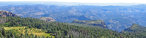
This Hike Guide is edited to only cover the author's "recommended", most enjoyable out-n-back part of this easy to navigate off-trail hike section: to the Plateau Viewpoint Areas (1.2ml roundtrip, 169 AEG). If one desires to continue to the Murphy 7732 Benchmark Summit, this out-n-back will be 2.1mls at 340 AEG. The Official posted GPS Route for this hike covers both options.


    Check out the Official Route and Triplogs.
    Leave No Trace and +Add a Triplog after your hike to support this local community.
    WARNING! Hiking and outdoor related sports can be dangerous. Be responsible and prepare for the trip. Study the area you are entering and plan accordingly. Dress for the current and unexpected weather changes. Take plenty of water. Never go alone. Make an itinerary with your plan(s), route(s), destination(s) and expected return time. Give your itinerary to trusted family and/or friends.

     Permit $$
    None


     Directions
    or
     Road
    Strictly 4x4

    To hike
    From the PHX area:
    Hwy 60 East to Globe, AZ at Hwy 188 Intersection; Hwy 188 North to the Young Hwy 288 North Intersection; Hwy 288 North for ~25 miles to the signed Workman Creek Road (FR487) intersection; FR487 Southeast for ~6+ miles to unmarked Park/TH Start at Gps Coordinates 33.815578 -110.907718;
    page created by Grasshopper on Aug 06 2019 10:23 am
     90+° 8am - 6pm kills
    helpcorrectionissue

    end of page marker