username
X
password
register
for free!
help
  This is likely a great time to hike this trail!  Check out "Preferred" months below, keep in mind this is an estimate.
 

Fort Valley Trail System, AZ

Guide 3 Triplogs  0 Topics
  3 of 5  
Fav
Wish
0
details
drive
no permit
forecast
map
stats
photos
triplogs
topics
location
2 3 0
Statistics
tap row or icons for details
Distance Round Trip 20 miles
Trailhead Elevation 7,236 feet
Photos Viewed All MineFollowing
12  2025-07-09
Fort Valley/AZT Loop
fricknaley
2  2024-08-10 ScaredyCat
Author
author avatar Guides 595
Routes 0
Photos 0
Trips 247 map ( 429 miles )
Age ?
Location
Associated Areas
list map done
Flagstaff Region
Historical Weather
Trailhead Forecast
Expand Map
Preferred Jun, Jul, Sep, Oct
Sun  6:02am - 6:48pm
1 Route
 
1 Alternative


  Likely In-Season!
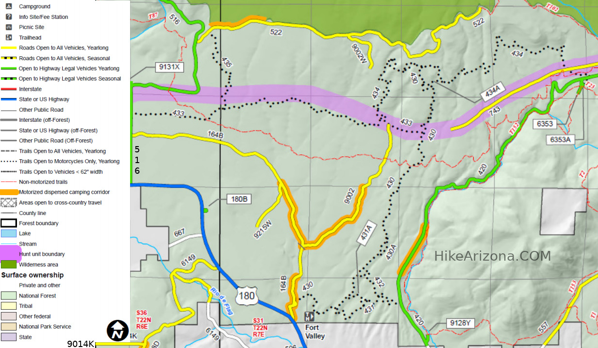
A collection of loop trails open to multi-use from hiking to biking, to motor bikes. Be aware of that. The trail tracks appear to be mostly tire over foot traffic. These trail link to other popular local hikes and trails.


Much of this area was thinned in 2018 and 2019, and is now very open and sunny.
remove free decal offer
Located at the base of the San Francisco Peaks, the Fort Valley Trail System was designed primarily for connecting popular mountain biking trails. This system is a multi-use trail to be used by bicycles, hikers, horses and motorcycles. Several sections of the trail were designed by a local biking organization to provide a more challenging ride for the more experienced mountain bike rider. The trail consists of loops that link with the Schultz Creek, Dry Lake Hill and Mt. Elden trail system.

Fort Valley trail is in the Chimney Springs area, just north of Flagstaff. The area has a gradual sloping terrain that consists of several shallow canyons and sweeping views of the San Francisco Peaks. Ponderosa pine and Gambel oak trees are the primary type of vegetation with New Mexico locust and an occasional hedgehog cactus.
  • Map
    guide related
    Map


Check out the Triplogs.
Leave No Trace and +Add a Triplog after your hike to support this local community.
WARNING! Hiking and outdoor related sports can be dangerous. Be responsible and prepare for the trip. Study the area you are entering and plan accordingly. Dress for the current and unexpected weather changes. Take plenty of water. Never go alone. Make an itinerary with your plan(s), route(s), destination(s) and expected return time. Give your itinerary to trusted family and/or friends.

 Permit $$
no fees or permits reported

if incorrect tell us about it


 Directions
or
 Road
FR / Dirt Road / Gravel - Car Okay

To hike
From Flagstaff, take US 180 north to FR 164B. Proceed 400 to a dirt road, and turn right following the small signs. The TH should be obvious.
page created by Jim on Aug 16 2019 12:02 pm
 90+° 8am - 6pm kills
helpcorrectionissue

end of page marker