username
X
password
register
for free!
help
  🔥

East Baldy Trail #95 to Hoodoo Overlook, AZ

Guide 16 Triplogs  0 Topics
  4.7 of 5  
Fav
Wish
0
details
drive
no permit
forecast
🔥
route  
stats
photos
triplogs
topics
location
54 16 0
Statistics
tap row or icons for details
Difficulty 2 of 5
Route Finding 1 of 5
Distance One Way 2.5 miles
Trailhead Elevation 9,373 feet
Elevation Gain 815 feet
Accumulated Gain 855 feet
Avg Time One Way 1 hour
Kokopelli Seeds 5.35
 Interest Perennial Creek
 Backpack Yes
unreported if dogs are allowed
editedit > ops > dogs to adjust
feature photo
Photos Viewed All MineFollowing
Inaugural Calculation on Button Tap!
15  2025-06-20
Mt Baldy from Winn Campground
fricknaley
30  2020-10-20
Thomas Baldy
DixieFlyer
9  2020-09-20
Mount Baldy Loop
kyleGChiker
3  2020-08-07
East Baldy Trail #95 to West Baldy Overlook
hiking_arizona
20  2020-07-11
Mt Baldy Super Loop
jacobemerick
7  2019-09-21
Mt Baldy Super Loop
LindaAnn
54  2019-08-29 hiking_arizona
13  2010-08-15
Mount Baldy Loop
nonot
Author
author avatar Guides 2
Routes 2
Photos 75
Trips 9 map ( 33 miles )
Age Male Gender
Location
Associated Areas
list map done
Alpine Region
Historical Weather
Trailhead Forecast
Radar Map
Expand Map
Preferred Jun, Oct, Jun, Oct → Early
Seasons   Summer to Early Winter
Sun  5:54am - 6:40pm
Official Route & 1 Rt
 
6 Alternative
 
Historic Fire Perimeteracres
🔥 2011 Wallow Fire29


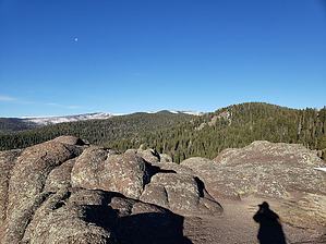
Fabulous shorter Baldy Option
by hiking_arizona

Overview
Get a taste of the Mt Baldy Wilderness when you don't have the time or energy to reach the trail's end/jct at mile 7.5


This is an often missed option & gem of a hike, especially for those who are only familiar with the nearby West Baldy Trail #94, which this trail intersects/reaches at mile 7.5 and wants a great 2.5-mile one-way option of a hike.
remove free decal offer
Hike
This hike initially follows the East Fork of the Little Colorado River as well as some often lush meadows for about 1.5 miles before a 900-foot climb to some beautiful hoodoos and incredible views of the Mt Baldy Wilderness as well as the surrounding area from the nearly 10,200-foot overlook.

Warning
Snow can be problematic sometimes as early as mid-October and present on the upper portions of the trail as late as June.

Large Groups Not Allowed
This trail is part of the Mount Baldy Wilderness area, and as such, the US Forest Service has a group size maximum of 12 hikers & a maximum of 6 for overnight backpacking.

2019-08-31 hiking_arizona


    Check out the Official Route and Triplogs.
    Leave No Trace and +Add a Triplog after your hike to support this local community.

    One-Way Notice
    This hike is listed as One-Way.

    When hiking several trails on a single "hike", log it with a generic name that describes the hike. Then link the trails traveled, check out the example.
    WARNING! Hiking and outdoor related sports can be dangerous. Be responsible and prepare for the trip. Study the area you are entering and plan accordingly. Dress for the current and unexpected weather changes. Take plenty of water. Never go alone. Make an itinerary with your plan(s), route(s), destination(s) and expected return time. Give your itinerary to trusted family and/or friends.

     Permit $$
    None


     Directions
    or
     Road
    Paved - Car Okay

    To East Baldy Trailhead
    From Phoenix area take highway 87 to Payson, then 260 to Sunrise junction, then State Road 273 about 10 miles to turn off for East Baldy Trail. On topo, it is between Gabaldon Horse Camp & Lee Valley Reservoir.

    Start at the paved lot.

    Snow Plowing
    Highway Department typically plows Highway 273 past the ski area until December 31 but after which road is gated till often mid-April. Contact the Springerville highway department office at 928-333-4495 for the latest info.

    Google Maps Search: East Baldy Trailhead, Greer, AZ

    Tip
    The East Baldy Trailhead can still be found on some maps under its former name of the Phelps Trailhead.

    Alternative
    Very unusual but if the lot is full please there is a secondary unpaved trailhead next door at Gabaldon Campground. It is reserved for horse camping but there's a small dirt area for general parking. The trails merge within a quarter of a mile of their respective starting points.

    From PHX (I-10 & AZ-51) - 3 h 58 min (223 miles)
    From TUC (Jct 1-10 & Grant) - 4 h 29 min (233 miles)
    From FLG (Jct I-17 & I-40) - 3 h 8 min (187 miles)
    page created by hiking_arizona on Aug 31 2019 7:31 pm
     90+° 8am - 6pm kills
    helpcorrectionissue

    end of page marker