 Route Editor

| Guide | ♦ | 4 Triplogs | 0 Topics |
details | drive | no permit | forecast | route |
stats |
photos | triplogs | topics | location |
| 42 | 4 | 0 |
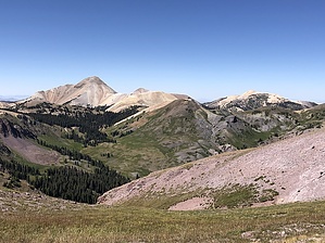
Double county highpoints by LindaAnn Short, but steep, trail to the highpoint of the Tushar range, and the county highpoint of both Beaver and Piute counties. Hike: The hike begins on the east side of FS-123. It is not well marked, there are a couple of signs prohibiting motor vehicles, but nothing really indicating this is the trail to Delano Peak. There is a well worn trail heading southeast up from the road. About 100' into the hike, there is another sign marked Fishlake Trail.
Shortly after passing a few remaining old fence posts, the Jeep trail fades, and the trail becomes single track as it winds up through the rocks. While most of the other peaks in the area are talus slopes (be sure to admire the views of Mt Belknap and Mt Baldy behind your left shoulder), Delano is mostly soil covered, with very little talus. In late summer, the slopes have an abundance of wildflowers. In a few areas, the trail fades slightly; just keep heading uphill and you will pick it up again. There are a handful of cairns along the trail as well on the upper half of the hike. As you are nearing the summit, the trail fades away for a while. Continue uphill, possibly spotting a cairn here and there. Just as you are topping out, you realize it's a false summit. No need to be disappointed, the true summit is just a short distance away to your right. The trail becomes more defined again for these last few moments to the summit, and the views to the east open up as well. Keep an eye out for mountain goats, as they do inhabit the range. There is a large sign at the summit, and a mailbox as well. There are some places to sit among the rocks up top and take in the amazing views in all directions. Once done, you can take the same trail back downhill, or loop around to the north and west on a trail visible in the distance until it reaches FS-123, then following FS-123 back downhill 1.50 miles to your car. Check out the Official Route and Triplogs. Leave No Trace and +Add a Triplog after your hike to support this local community. One-Way Notice This hike is listed as One-Way. When hiking several trails on a single "hike", log it with a generic name that describes the hike. Then link the trails traveled, check out the example. | ||||||||||||||||||||||||||||||||||||||||||||||||||||||||||||||||||||||||||||||||||||||||||||


