|
tap row or icons for details
|
| Difficulty |
|
5 of 5 |
| Distance One Way |
|
6 miles |
| Trailhead Elevation |
|
6,926 feet |
| Elevation Gain |
|
7,242 feet |
| Kokopelli Seeds |
|
30.13 |
| Interest Seasonal Waterfall, Perennial Waterfall, Seasonal Creek, Perennial Creek & Peak | | unreported if dogs are allowed
editedit > ops > dogs to adjust |
| | |
|
|
list |
map |
done |
Northern Region |
| | |
|
| |
|
|
Historical Weather |
| Trailhead Forecast | | |
|
 |
|
|
| Preferred Jul, Aug, Sep, Jun |
|
|
| | |
Named Locations Coordinate Links
| |
|
| help future hikers |
| post a gps route now |
| | |
| |
|
|
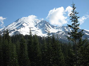
 Overview: Overview: Known as the standard route, the trail starts at the Bunny Flat trailhead. Mt Shasta is the 2nd highest mountain in the Cascades. A no fee wilderness permit is required and a $15.00 summit permit for climbs above 10,000'.
Check out the Triplogs. NoteThis is a difficult hike. Arrive fit and prepared or this could get ugly. One-Way NoticeThis hike is listed as One-Way. When hiking several trails on a single "hike", log it with a generic name that describes the hike. Then link the trails traveled, check out the example. |
 Route Editor


