Route Editor

| Guide | ♦ | 1 Triplog | 0 Topics |
details | drive | no permit | forecast | route |
stats |
photos | triplog | topics | location |
| 15 | 1 | 0 |
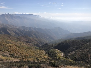
Avocado Valley Views by LindaAnn  History: Nordhoff Peak, and the nearby town of Ojai, was originally named for Charles Nordhoff with the New York Evening Post back in the late 1800's. During WWI, anti-German sentiment led to the town being renamed Ojai due to Charles Nordhoff having been born in Germany, however, the peak retained the Nordhoff name.
After leaving the orchards behind, the vegetation is mostly scrub oak, chaparral, and manzanita as you get higher. Vegetation and terrain are very reminiscent of the Mazatzal Mountains. The trail heads generally northeast for the first couple of miles, then turns northwest for the next four miles, following Gridley Canyon most of the way. About 2.75 miles in, you will reach Gridley Spring, which looks to be a reliable source of water. While the trail has steadily gained elevation since the beginning of the hike, it gets a little steeper after the spring, and steepens again while ascending the switchbacks up the ridge. Evidence of the Dec 2017 Thomas Fire is very evident while hiking the switchbacks, although the vegetation is rebounding nicely. Near the top of the switchbacks, there are a few pine trees along the trail, but only one seems to have survived the fire. About six miles into the hike, you will reach Nordhoff Ridge Rd. From here, turn left and continue up the road to Norhoff Peak a little over a mile away. The fire lookout platform is easily visible as you hike towards it. After about a mile on the road, turn right to take the side road up to the peak. As of Sept 2019, there was a laminated paper sign at the turn, but the turn would be evident even without the sign. From here, follow the road around and up to the fire lookout. At the top, there is a fire ring, picnic bench, and plenty of space to walk around and admire the view in all directions. There's a steep staircase to the platform for a higher vantage point. Views of Ojai Valley are immediately below to the south, with the Pacific Ocean visible beyond on clear days. Mountains surround in all other directions. Once done, retrace your steps back downhill. With the easy grade and good trail surface, the 7+ miles back to the trailhead go by in a flash. This is probably a trail that could be hiked close to year-round. With the lack of shade, the hottest days might be a challenge, and occasional winter rains might best be avoided since most of the hike passes through a recent burn area. Check out the Official Route and Triplog. Leave No Trace and +Add a Triplog after your hike to support this local community. | |||||||||||||||||||||||||||||||||||||||||||||||||||||||||||||||||||||||||||||||||||||