 Route Editor

| Guide | ♦ | 2 Triplogs | 0 Topics |
details | drive | permit | forecast | route |
stats |
photos | triplogs | topics | location |
| 14 | 2 | 0 |
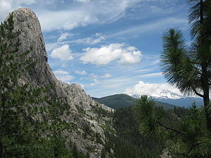
A View of the Ring of Fire by AZLOT69  History: Wintu Indians occupied this area for thousands of years and were superstitious of the formations and it is not believed they would venture into them. Early Europeans referred to this area as Devils Castle. The California Gold Rush led to strained relations with the Indians and the Battle of Castle Crags in 1855. Mining and lumbering flourished following the battle. In 1933 local interest managed to save a portion and make it a State Park, with the Forest Service completing adjacent wilderness designation in 1984.
Hike: The trailhead parking area only holds about 10 cars and is situated at the top of a knoll. The steep one mile single lane paved road to the top is basically cross your fingers and hope there is no oncoming traffic and that there is an open spot when you get there as there is little room to maneuver. There is a restroom at the trailhead and once situated the trail begins about a hundred feet to the west of the restroom off the road you arrived on. The first third of a mile is a level smooth trail on what seems to be an old flume trail cut into the side of a steep hill. Thick forest limits any views at this point. Arriving at a signed intersection bear left. A short steep serpentine brings you out to an opening where the Pacific Crest Trail crosses at a marked intersection. Continuing straight the trail continues up rather steeply under cover of trees. The heavy fall of needles make the trail smooth and comfortable. At one mile there is another marked intersection. This is Bobs Hat Trail, you can think about how they came up with that name as you continue straight. The trail gets steeper with a long sweeping switchback. Employing a hikers cadence can easily get you up to the next section nonstop without the traditional tortoise and the hare experience. At 1.25 miles you reach a false summit as the grade settles down and the forest opens up to the first views of the Crags. At 1.5 miles you encounter another marked intersection with the trail for Indian Spring. Generally there is filterable water at this short detour. Continuing straight you will catch the first views of Mt Shasta to the north. This active volcano dominates the skyline. As you enter into the Castle Crag Wilderness, the trail gets steeper and rocky. Some sections will have you using hands as well as your feet. Castle Dome comes into clear view with Mt Shasta as a backdrop. The Crags lie ahead as you make the final push up. The official trail ends at this point and you can spend as much time as you want exploring, climbing and enjoying the panoramic views. When finished return the way you came. Check out the Official Route and Triplogs. Note This is a moderately difficult hike. Leave No Trace and +Add a Triplog after your hike to support this local community. One-Way Notice This hike is listed as One-Way. When hiking several trails on a single "hike", log it with a generic name that describes the hike. Then link the trails traveled, check out the example. | ||||||||||||||||||||||||||||||||||||||||||||||||||||||||||||||||||||||||||||||||||||||||||||||||||||


