Route Editor

| Guide | ♦ | 1 Triplog | 0 Topics |
details | drive | no permit | forecast | map |
stats |
photos | triplog | topics | location |
| 20 | 1 | 0 |
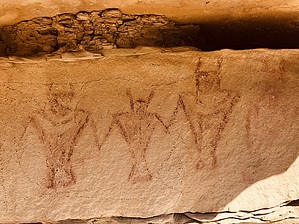
Sand In My Shoes by AZLOT69 Don’t attempt this road if wet. The corral and beyond are on BLM land but ranchers lease the land. Respect the land and close any gates you opened behind you. Hike The "road" becomes extremely sandy beyond the corral and basically a cow path. The surface is like talcum powder. Your destination lies ahead as you enter a canyon. Soon you come to a wash that has completely washed out the road. Follow the cow path. Quitchupah Creek is on your left. Soon a large canyon will enter from the right. This is your trigger to start looking for Rock Art in earnest.
Gate Policy: If a gate is closed upon arrival, leave it closed after you go through. If it is open, leave it open. Leaving a closed gate open may put cattle in danger. Closing an open gate may cut them off from water. Please be respectful, leave gates as found. The exception is signage on the gate directing you otherwise. Check out the Triplog. Leave No Trace and +Add a Triplog after your hike to support this local community. | ||||||||||||||||||||||||||||||||||||||||||||||||||||||||||||||||||||||||||||||||||||||