 Route Editor

| Guide | ♦ | 5 Triplogs | 0 Topics |
details | drive | no permit | forecast | route |
stats |
photos | triplogs | topics | location |
| 38 | 5 | 0 |
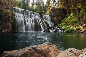
Waterfall Hat Trick by AZLOT69  The McCloud River is fed by streams draining the south slopes of Mt Shasta in the Cascade Mountain Range. Archaeologists determined that the Wintu Indians occupied this area seasonally, and used as a fishing and hunting base. Fishing for Salmon was particularly suitable due to several waterfalls that interfered with their progress upstream. T.B. Fowler homesteaded this land in the late 1800s and built cottages to accommodate travelers on the nearby stage road. With its rich history, the Forest Service acquired the property in a deal with a lumber company in 1932, and it has been a managed recreational area since. Hike Starting at the Lower Falls day-use area, you will find water available and a restroom. The McCloud River has a vigorous flow typically, and the sound of the river will be evident. Just a short quarter of a mile will bring you to an overlook of the Lower Falls. It's very popular with fishers, and it makes a great swimming hole, but the water is sure cold. Huge boulders provide ample open seating and places to relax to the sound of the stream and soak up the sun. The trail continues to the east along the river with a gradual grade. Vast stands of Ponderosa Pine line the river, which provides for the many birds and squirrels. Black bears frequent the area as well as bobcats. Keeping an eye on the river, you may see a river otter. The trail meanders but follows the river in sight the entire hike. At about a mile and a half, you can hear Middle Falls ahead. It is much more spectacular. The view of the falls is excellent with many large boulders inviting you to stay awhile and on a warm day enjoy the cool mist which accompanies the falls. Continuing on the trail, it does a switchback at this location as you have to get up and over the river channel to get to the upper falls, which lie about half a mile ahead. A couple more switchbacks bring you to a set of stairs to make the final ascent. The trail is fascinating in this section. It sits like a shelf in the basalt high above the river below. The Upper Falls are soon heard but not seen. The falls come into view if only partially coming around a corner. The river is more contained here, and the water is forced between basalt rock cliffs, causing increased turbulence. The power of the water cutting thru the rock is evident. There are several more viewpoints of the upper falls on the trail ahead, but none offer a full frontal view of the entire display. Never the less it is impressive. The official trail ends here, but you can continue for a distance. Getting your fill, return the way you came. Check out the Official Route and Triplogs. Leave No Trace and +Add a Triplog after your hike to support this local community. One-Way Notice This hike is listed as One-Way. When hiking several trails on a single "hike", log it with a generic name that describes the hike. Then link the trails traveled, check out the example. | ||||||||||||||||||||||||||||||||||||||||||||||||||||||||||||||||||||||||||||||||||


