 Route Editor

| Guide | ♦ | 2 Triplogs | 0 Topics |
details | drive | permit | forecast | route |
stats |
photos | triplogs | topics | location |
| 8 | 2 | 0 |
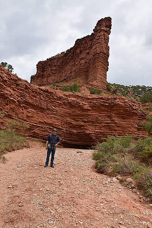
Mountain Below the Plains by markthurman53  Caprock Canyon like Palo Duro Canyon is located on the eastern edge of the Llano Estacado just south of Amarillo, Texas. The Llano Estacado is a plain that encompasses eastern New Mexico and Northwest Texas. Caprock Canyon is at the breaks of this plain and is drained by the Little Red River. The Spanish named the area “Hay Sierras Debajo De Los Llanos”, There are mountains beneath the plains. Geologically they are composed of Permian-Triassic Redbeds. The little Red River drains the park with two major streams, the South Prong and the North Prong of the Little Red River. In 1982 this became a Texas State Park and offers 30 miles of trails. Besides the scenic trails the other attraction are the Bison of which there are quite a few. UPPER SOUTH PRONG TRAIL
The South Prong of the Little Red River has two trails along it, The Lower and the Upper. The Upper South Prong starts at the end of the road in the park and continues to Fern Cave for a total of 3.2 miles and 800 feet AEG. This is one of the three challenging trails in the park, all 3 of these challenging trails head to the top of Haynes Ridge. The climb to the top of Haynes Ridge is at 2 miles in and climbs 500 feet in a half mile. If you are looking for a more leisurely hike you can turn around at the 2 mile point and still have a very scenic hike through the red rock canyon. Once on Haynes Ridge it is another 0.2 miles of level walking to the junction with the Haynes Ridge Trail and another 0.3 miles to Fern Cave and the end of the Trail. The last 0.2 miles to Fern Cave are fairly steep as you are descending from Haynes Ridge. Hike This is a very scenic trail as it follows along the upper reaches of the South Prong of the Little Red River. This is a well maintained trail and easy to follow. The red rock cliffs along this canyon form many interesting hoodoos and towers that appear to defy gravity. Throughout the red rock are layers of white Gypsum that cut horizontally and occasionally diagonally through it adding an interesting pattern to the formation. Keep an eye out also for Buffalo, on my trip up this canyon there was one lone buffalo in the upper reaches of the canyon. The Climb up to Haynes Ridge offers great views down the upper South Prong Canyon. Fern Cave is a must see, a shallow cave under a waterfall with ferns covering the cove almost entirely. This might be pretty impressive when the water is flowing over the falls. Even if the water isn’t flowing over the falls sit in the alcove and listen to the water dripping from the ferns. This hike to Fern cave is one way and you either have to return the way you came or take the Upper North Prong Trail back to your start point. This loop would make a 7.7 mile hike. Check out the Official Route and Triplogs. Leave No Trace and +Add a Triplog after your hike to support this local community. One-Way Notice This hike is listed as One-Way. When hiking several trails on a single "hike", log it with a generic name that describes the hike. Then link the trails traveled, check out the example. | |||||||||||||||||||||||||||||||||||||||||||||||||||||||||||||||||||||||||||||||||||||||||


