 Route Editor

| Guide | ♦ | 4 Triplogs | 0 Topics |
details | drive | permit | forecast | route |
stats |
photos | triplogs | topics | location |
| 4 | 4 | 0 |
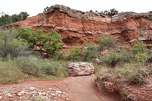
Mountains bellow the plains by markthurman53  Caprock Canyon like Palo Duro Canyon is located on the eastern edge of the Llano Estacado just south of Amarillo, Texas. The Llano Estacado is a plain that encompasses eastern New Mexico and Northwest Texas. Caprock Canyon is at the breaks of this plain and is drained by the Little Red River. The Spanish named the area “Hay Sierras Debajo De Los Llanos”, There are mountains beneath the plains. Geologically they are composed of Permian-Triassic Redbeds. The little Red River drains the park with two major streams, the South Prong and the North Prong of the Little Red River. In 1982 this became a Texas State Park and offers 30 miles of trails. Besides the scenic trails the other attraction are the Bison of which there are quite a few. LOWER NORTH PRONG TRAIL Overview The lower North Prong Trail has no direct access and therefore access from the West is via the North Prong Spur Trail at the North Prong Primitive Camping Trailhead. Access from the East end is at the Wild Horse Campsite Trailhead via the wild Horse Trail. On the East end this trail starts at the junction of the South Prong Little Red River and the North Prong. This trail follows along the North Prong pretty much the whole way, sometimes in the creek other times either on the right or left bank. It is fairly easy level walking with minor elevation gains or losses. The trail ends on the West end at the junction of the Upper North Prong and the North Prong Spur Trail. The GPS route posted for this description does not include the far eastern 0.5 mile portion between the Trailhead along the Wild Horse Trail and the junction with the Mesa Spur Trail. The full trail is 2.9 miles. Hike Since this is a trail that follows along a creek, views of the park are limited but it is more than made up for by the rock formations that the creek cuts through. Redbed clay banded with gypsum and capped with a thicker band of calcium carbonate rock that resembles marble make for interesting formations all along this trail. At 0.5 miles in from the East end is the junction with the Mesa Spur Trail that leads to the Mesa Trail that wanders around the mesa above before exiting further west. Keep an eye out for buffalo in the grassy areas along the creek. Mud swallow nests can be seen on some of the redbed cliffs below the caprocks. This trail makes up one trail of a loop hike that would include the Lower South Prong Trail and the North prong Spur Trail. Check out the Official Route and Triplogs. Leave No Trace and +Add a Triplog after your hike to support this local community. One-Way Notice This hike is listed as One-Way. When hiking several trails on a single "hike", log it with a generic name that describes the hike. Then link the trails traveled, check out the example. | ||||||||||||||||||||||||||||||||||||||||||||||||||||||||||||||||||||||||||||||||||||||||||||


