 Route Editor

| Guide | ♦ | 2 Triplogs | 0 Topics |
details | drive | permit | forecast | route |
stats |
photos | triplogs | topics | location |
| 7 | 2 | 0 |
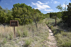
Mountains below the plains by markthurman53  Caprock Canyon like Palo Duro Canyon is located on the eastern edge of the Llano Estacado just south of Amarillo, Texas. The Llano Estacado is a plain that encompasses eastern New Mexico and Northwest Texas. Caprock Canyon is at the breaks of this plain and is drained by the Little Red River. The Spanish named the area “Hay Sierras Debajo De Los Llanos”, There are mountains beneath the plains. Geologically they are composed of Permian-Triassic Redbeds. The little Red River drains the park with two major streams, the South Prong and the North Prong of the Little Red River. In 1982 this became a Texas State Park and offers 30 miles of trails. Besides the scenic trails the other attraction are the Bison of which there are quite a few. JOHN HAYNES RIDGE TRAIL
The John Haynes Ridge Trail has access points from the East along the North Prong Spur Trail or from the West along the Upper South Prong Trail. John Haynes Ridge separates the Upper North and South Prong Canyons. This 2.4 mile trail follows along a ridge with views to the North and East of Caprock Park. Nowhere else in the park are the views as grand as along this ridge. This ridge is also the highest point in the park. Hike From the West the trail starts on top of the ridge, the 600 foot ascent to the ridge is been done on either the Upper North Prong Trail or the Upper South Prong Trail. The 2 mile hike to the vista point is along a fairly flat trail with the exception of a 100 foot descent from the approximately 3200 foot peak that is the high point in the park. The vista point is marked and is about 100 yards off trail. Pretty much all of the park can be seen from this vista and depending on how clear much further. From the vista point the trail drops 500 feet in 0.4 miles. The lower portion of this trail is very steep and rocky but the footing is good, a lot of rock scrambling. I believe I would rather descend this portion of the trail than ascend it. Once off the ridge it is less than a tenth of a mile to the North Prong Trail. Check out the Official Route and Triplogs. Leave No Trace and +Add a Triplog after your hike to support this local community. One-Way Notice This hike is listed as One-Way. When hiking several trails on a single "hike", log it with a generic name that describes the hike. Then link the trails traveled, check out the example. | ||||||||||||||||||||||||||||||||||||||||||||||||||||||||||||||||||||||||||||||||||||||||||||


