 Route Editor

| Guide | ♦ | 5 Triplogs | 0 Topics |
details | drive | permit | forecast | route |
stats |
photos | triplogs | topics | location |
| 2 | 5 | 0 |
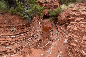
Mountains below the plains by markthurman53  Caprock Canyon like Palo Duro Canyon is located on the eastern edge of the Llano Estacado just south of Amarillo, Texas. The Llano Estacado is a plain that encompasses eastern New Mexico and Northwest Texas. Caprock Canyon is at the breaks of this plain and is drained by the Little Red River. The Spanish named the area “Hay Sierras Debajo De Los Llanos”, There are mountains beneath the plains. Geologically they are composed of Permian-Triassic Redbeds. The little Red River drains the park with two major streams, the South Prong and the North Prong of the Little Red River. In 1982 this became a Texas State Park and offers 30 miles of trails. Besides the scenic trails the other attraction are the Bison of which there are quite a few. NORTH PRONG SPUR TRAIL
The North Prong Spur trail starts at the posted trailhead along the park road about 0.75 miles from the end of the road. This 1.5 mile spur trail provides access to the Upper and Lower North Prong Trails and the John Haynes Ridge Trail. This trail connects the South Prong of the Little Red River to the North Prong following along the east end of John Haynes Ride. Three Loop Hikes can be done using this trail. The first would be using the Upper North Prong Trail and the John Haynes Trail, The second using the Upper North Prong and Upper South Prong Trails and the third using the Lower North Prong and Lower South Prong Trails. Hike This trail is not a particularly interesting trail in itself but it connects you to trails that promise to be very interesting. This trail follows along what looks like an old jeep trial that skirts along the east side of John Haynes Ridge. The trail stays fairly level with lots of little ups and downs as you cross over many smaller creeks. The stream beds are quite interesting in that they are cutting through redbed rock that have layers of more resistant gypsum making for some interesting pools and cascading mini falls. Very interesting photo opportunities if that’s what you are looking for. The John Haynes Ridge trail branches off from this trail at about 0.5 miles in. This junction is unmarked but there is a wood bench at this spot. Another mile in along a fairly uneventful trail and you come to the end at the junction with the Upper North Prong Trail and the Lower North Prong Trail. Check out the Official Route and Triplogs. Leave No Trace and +Add a Triplog after your hike to support this local community. One-Way Notice This hike is listed as One-Way. When hiking several trails on a single "hike", log it with a generic name that describes the hike. Then link the trails traveled, check out the example. | ||||||||||||||||||||||||||||||||||||||||||||||||||||||||||||||||||||||||||||||||||||||||||||


