 Route Editor

| Guide | ♦ | 3 Triplogs | 0 Topics |
details | drive | permit | forecast | route |
stats |
photos | triplogs | topics | location |
| 4 | 3 | 0 |
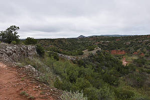
Mountains below the plains by markthurman53  Caprock Canyon like Palo Duro Canyon is located on the eastern edge of the Llano Estacado just south of Amarillo, Texas. The Llano Estacado is a plain that encompasses eastern New Mexico and Northwest Texas. Caprock Canyon is at the breaks of this plain and is drained by the Little Red River. The Spanish named the area “Hay Sierras Debajo De Los Llanos”, There are mountains beneath the plains. Geologically they are composed of Permian-Triassic Redbeds. The little Red River drains the park with two major streams, the South Prong and the North Prong of the Little Red River. In 1982 this became a Texas State Park and offers 30 miles of trails. Besides the scenic trails the other attraction are the Bison of which there are quite a few. MESA AND MESA SPUR TRAIL
The Mesa Trail has no trailhead along the park road; access is via the Wild Horse Trail from the Wild Horse Campground. The East access point is 1.6 miles in on the Wild Horse Trail and the West access point is 0.7 miles along the Wild Horse Trail then 0.5 along the Lower North Prong Trail where the junction with the Mesa Spur trail is. A short 0.5 miles up the Mesa Spur Trail connects you up with the Mesa Trail. For this description I have included both the Mesa Trail and the Mesa Spur Trail together. The GPS route does not show the complete Loop on the Mesa Trail. Hike From the East entrance the Mesa trail begins at a signed trail junction along the Wild Horse Trail. The trail climbs up onto a Mesa about 100 feet in a quarter mile then over the next mile will ascend another 100 feet. At 0.8 miles in the trail comes to a junction, either direction will bring you back to this same point. This is the beginning of the loop portion of the trail and the loop is 1.4 miles long. If you go left at this junction in 0.5 miles is the junction with the Mesa Spur Trail. Going right at the junction will get you to the Mesa Spur Trail in 1 mile. The Mesa Spur Trail is 0.5 miles long and takes you to the signed junction with the Lower North Prong Trail. There are not a lot of views along the Mesa Trail but at times you do get a glimpse of the Southeast portion of the park. The vegetation on the mesa is fairly thick with juniper and at times visibility is just 10 yards. When I was on this trail on the upper part of the Mesa I ran into what I thought were just two buffalo, then two more and before long I realized I was in the middle of about 20 buffalo. They were quite docile but as a word of caution they can be quite dangerous if spooked, not because they are vicious but because 2000 pounds of beef on the hoof running scared is not something you want to be in the way of. These trails like many of the other trails in the park lend themselves quite nicely to larger loop hikes. Check out the Official Route and Triplogs. Leave No Trace and +Add a Triplog after your hike to support this local community. One-Way Notice This hike is listed as One-Way. When hiking several trails on a single "hike", log it with a generic name that describes the hike. Then link the trails traveled, check out the example. | ||||||||||||||||||||||||||||||||||||||||||||||||||||||||||||||||||||||||||||||||||||||||||||


