 Route Editor

| Guide | ♦ | 2 Triplogs | 0 Topics |
details | drive | permit | forecast | route |
stats |
photos | triplogs | topics | location |
| 3 | 2 | 0 |
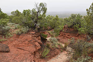
Mountains below the plains by markthurman53  Caprock Canyon like Palo Duro Canyon is located on the eastern edge of the Llano Estacado just south of Amarillo, Texas. The Llano Estacado is a plain that encompasses eastern New Mexico and Northwest Texas. Caprock Canyon is at the breaks of this plain and is drained by the Little Red River. The Spanish named the area “Hay Sierras Debajo De Los Llanos”, There are mountains beneath the plains. Geologically they are composed of Permian-Triassic Redbeds. The little Red River drains the park with two major streams, the South Prong and the North Prong of the Little Red River. In 1982 this became a Texas State Park and offers 30 miles of trails. Besides the scenic trails the other attraction are the Bison of which there are quite a few. CANYON RIM TRAIL
The Canyon Rim Trail is on the Easternmost portion of the park along a ridge that is just to the West of Holmes Canyon. The trailhead is at the Honey Flat Camping area and ends 2.8 miles later at the junction with the Wild Horse Trail and the Little Red River. This trail offers views to the east over Holmes Canyon and to the west over the vast majority of Caprock Park. Like a lot of the other trails in this park this trail follows along what looks like an old jeep trail. Hike The trailhead for the Canyon Rim Trail is at the Honey Flat Camping Area just north of the restrooms and on the south end of the Prairie Dog town. There are views to the East over Holmes Canyon and to the west over the vast majority of the park. I can’t say how great the views were because on the morning I hiked this trail it was foggy. The Canyon Rim Trail can be done as part of a larger loop hike involving the Wild Horse, Lower South Prong and returning on the Eagles Peak Trail. If a long 17 mile hike is what you are looking for then I recommend what I call the Park outer perimeter loop. This loop would start out on the Canyon Rim Trail then on the Mesa and Mesa Spur to the North Prong trails and return on the South Prong Trail to the Eagle Peak Trail to get back where you started. Check out the Official Route and Triplogs. Leave No Trace and +Add a Triplog after your hike to support this local community. One-Way Notice This hike is listed as One-Way. When hiking several trails on a single "hike", log it with a generic name that describes the hike. Then link the trails traveled, check out the example. | |||||||||||||||||||||||||||||||||||||||||||||||||||||||||||||||||||||||||||||||||||||||||


