 Route Editor

| Guide | ♦ | 1 Triplog | 0 Topics |
details | drive | permit | forecast | route |
stats |
photos | triplog | topics | location |
| 4 | 1 | 0 |
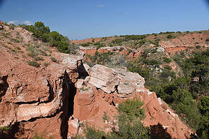
Mountains below the plains by markthurman53  Caprock Canyon like Palo Duro Canyon is located on the eastern edge of the Llano Estacado just south of Amarillo, Texas. The Llano Estacado is a plain that encompasses eastern New Mexico and Northwest Texas. Caprock Canyon is at the breaks of this plain and is drained by the Little Red River. The Spanish named the area “Hay Sierras Debajo De Los Llanos”, There are mountains beneath the plains. Geologically they are composed of Permian-Triassic Redbeds. The little Red River drains the park with two major streams, the South Prong and the North Prong of the Little Red River. In 1982 this became a Texas State Park and offers 30 miles of trails. Besides the scenic trails the other attraction are the Bison of which there are quite a few. EAGLE POINT TRAIL
The Eagle Point trail connects the upper park road near the entrance to the lower park road along the South Prong of the Little Red River. The marked lower trailhead is along the park road near Eagle point. Hike The lower end of this trail is along what looks like an old jeep trail, it heads in a Southeasterly direction to pass around Eagle Point then heads in a more Southerly direction the rest of the way. At 0.2 miles in there is a natural bridge that passes under the trail. Exiting the trail you can pass through this natural bridge. This is probably the high light of this trail. There are a couple of ravines that must be crossed before getting to the summit of the trail and because of these ravines the total AEG is close to 300 feet even though the elevation difference between the two ends of the trail is only 175 feet. From the upper end of the trail there are good views of the South Prong in its entirety. To the Northwest the John Haynes Ridge can be seen. This trail along with the Canyon Rim Trail can be connected to form a larger loop hike that I call the Caprock Canyon Perimeter Loop. This loop ties together the Canyon Rim, Mesa trails, North Prong Trails the South Prong Trails and ending on the Eagle Point Trail. Around 17 miles with about 2000 AEG. Check out the Official Route and Triplog. Leave No Trace and +Add a Triplog after your hike to support this local community. One-Way Notice This hike is listed as One-Way. When hiking several trails on a single "hike", log it with a generic name that describes the hike. Then link the trails traveled, check out the example. | ||||||||||||||||||||||||||||||||||||||||||||||||||||||||||||||||||||||||||||||||||||||||||||


