username
X
password
register
for free!
help
 This is likely a great time to hike this trail!  Check out "Preferred" months below, keep in mind this is an estimate.
 

Hell Brook Trail, VT

Guide 1 Triplog  0 Topics
  0 of 5  
Fav
Wish
0
details
drive
no permit
forecast
route  
stats
photos
triplog
topics
location
12 1 0
Statistics
tap row or icons for details
Difficulty 4.5 of 5
Distance One Way 1.5 miles
Trailhead Elevation 1,768 feet
Elevation Gain 2,277 feet
Accumulated Gain 2,279 feet
Kokopelli Seeds 9.09
 Dogs not allowed
feature photo
Photos Viewed All MineFollowing
Will recalculate on button tap!
12  2019-09-25 Stoic
Author
author avatar Guides 595
Routes 0
Photos 0
Trips 247 map ( 429 miles )
Age ?
Location
Associated Areas
list map done
Northwest Region
Historical Weather
Trailhead Forecast
Radar Map
Expand Map
Preferred Sep, Jun, May, Aug
Sun  5:18am - 6:21pm
Official Route & 1 Rt
 
0 Alternative


remove free decal offer

 Likely In-Season!
Overview
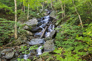
This trail is the Quickest and hardest way up to the top of Mount Mansfield. The trail ends on the Long Trail.


Continue on the long trail to the summit. It adds 0.25 miles and 350 ft to the top. If 2623 ft gain isn't enough for 1.75 miles, there is an Adams Apple cut off trail that gives you 2720 ft for the same 1.75 miles.


    Check out the Official Route and Triplog.

    Note
    This is a more difficult hike. It would be unwise to attempt this without prior experience hiking.
    Leave No Trace and +Add a Triplog after your hike to support this local community.

    One-Way Notice
    This hike is listed as One-Way.

    When hiking several trails on a single "hike", log it with a generic name that describes the hike. Then link the trails traveled, check out the example.
    WARNING! Hiking and outdoor related sports can be dangerous. Be responsible and prepare for the trip. Study the area you are entering and plan accordingly. Dress for the current and unexpected weather changes. Take plenty of water. Never go alone. Make an itinerary with your plan(s), route(s), destination(s) and expected return time. Give your itinerary to trusted family and/or friends.

     Permit $$
    no fees or permits reported

    if incorrect tell us about it


     Directions
    or
     Road
    Paved - Car Okay

    To hike
    page created by Stoic on Oct 21 2019 8:36 pm
     90+° 8am - 6pm kills
    helpcorrectionissue

    end of page marker