 Route Editor

| Guide | ♦ | 6 Triplogs | 0 Topics |
details | drive | permit | forecast | 🔥 route |
stats |
photos | triplogs | topics | location |
| 60 | 6 | 0 |
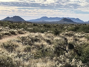
Rolling Hills by MEWhiteman  Overview OverviewThis section of the Maricopa Trail links the Bronco and Granite Mountain sections. It is a wide single track with long views as the trail goes over rolling terrain descending gradually. It is well signed and easy to follow but has no water. It is accessed from the north at the Tonto Trailhead at the Cave Creek District Ranger station on Bartlett Dam Road. From the south, it is accessed via trail from Granite Mountain Trailhead in the McDowell Sonoran Preserve (MSP) or by ATV/4WD dirt tracks at the MSP border. Hike This one-way description is in a southbound direction although I did it as an out and back hike. The trail begins between two signs on the right at the north end of the ranger station visitor parking lot. At 0.20 miles (N33.84987° W111.82659°) the spur trail intersects with the Maricopa Trail. Turn right to head south toward MSP which is this hike.
At 3.60 miles (N33.81490° W111.83366°) go through a gate and finish at the northern border of the McDowell Sonoran Preserve at 3.73 miles (N33.81415° W111.83273°). There is a fence and signage as well as a pass-through. Two 4x4 roads converge here, 2090 and 513. The Maricopa Trail follows the Dove Valley Trail once inside the MSP. If you plan on returning to the ranger station, you'll add another 494' of AEG. Gate Policy: If a gate is closed upon arrival, leave it closed after you go through. If it is open, leave it open. Leaving a closed gate open may put cattle in danger. Closing an open gate may cut them off from water. Please be respectful, leave gates as found. The exception is signage on the gate directing you otherwise.
Check out the Official Route and Triplogs. Leave No Trace and +Add a Triplog after your hike to support this local community. One-Way Notice This hike is listed as One-Way. When hiking several trails on a single "hike", log it with a generic name that describes the hike. Then link the trails traveled, check out the example. | ||||||||||||||||||||||||||||||||||||||||||||||||||||||||||||||||||||||||||||||||||||||||||||||


