Route Editor

| Guide | ♦ | 2 Triplogs | 0 Topics |
details | drive | permit | forecast | route |
stats |
photos | triplogs | topics | location |
| 107 | 2 | 0 |
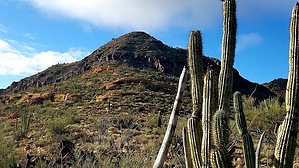
El diablo made me do it! by DixieFlyer  Overview OverviewThe Diablo Mountains are a mountain range within the Organ Pipe Cactus National Monument(OPCNM). This guide provides a route and description for a hike to the range high point (3,372'). Hike This hike is totally off-trail and it begins and ends at the Estes Canyon Picnic Area on Ajo Mountain Drive. This location also serves as the trailhead for the hike to Mount Ajo, and it would certainly be possible to hike both on the same day.
The climb to the top gets a bit steep as you near the summit -- you'll gain 300' in elevation over the last 0.15 miles. Fortunately, the footing is mostly solid, making the ascent doable. In fact, the footing was good enough that the descent was easier than the ascent. The default GPS track for this guide goes up to the summit on the north side of the peak. It is perhaps a little less steep of a climb on the west side of the peak, and some may wish to try to ascend or descend from that direction. To get back to the trailhead, simply reverse course and go back the way that you came. Other than the steep section just below the peak, this is a relatively easy off-trail hike. This area is totally exposed to the sun and it can get quite hot in the warmer months; hence, most would prefer to do this hike in winter or early spring. Going in February or March will often have the added benefit of wildflowers and cacti blooming. Water Sources There is no water along the hike, but with the short distance of the hike lack of water should not be an issue. Red Tape 2019 Entrance fees: * $25 per vehicle, $15 per pedestrian or cyclist. Good for 7 days. * Free with Interagency Annual passes. * Free with Golden Age, Senior, Access Lifetime, and Military Annual passes. Facilities There is a restroom, but no water, at the trailhead. Warning The 31-mile southern boundary of the OPCNM is the border between the United States and Mexico. As such, it is an area where people cross the border illegally. However, it is unlikely that park visitors will encounter illegal activity in the OPCNM -- migrants and smugglers want to evade detection and will therefore try to avoid contact with other people. The section of the park where this hike takes place is near a popular trailhead and is near Ajo Mountain Drive; the author of this guide saw no evidence of illegal activity when doing this hike in December 2019. Check out the Official Route and Triplogs. Note This is a moderately difficult hike. Leave No Trace and +Add a Triplog after your hike to support this local community. | ||||||||||||||||||||||||||||||||||||||||||||||||||||||||||||||||||||||||||||||||||||||||