Route Editor

| Guide | ♦ | 14 Triplogs | 1 Topic |
details | drive | no permit | forecast | 🔥 route |
stats |
photos | triplogs | topic | location |
| 209 | 14 | 1 |
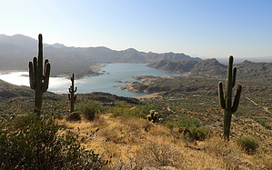
A Simpson worthy Roller Coaster by outdoor_lover  Overview OverviewThis may be just a small bump on the maps, but it's high enough to be worthy of setting a Benchmark. And you come to a full understanding of why, when you top out. It's a rather solitary High Point and the views go for miles in all directions. The proximity of this little Peak to Bartlett Lake promises spectacular views of the lake all the way up and the Hike delivers just that. The ridgeline you follow is a Roller Coaster ride, but when you jump on, each Hill provides unique views of the lake. The views will suck you in, enticing you to get to the next High Point for the next, different perspective. By the time you reach the point where you are finally ascending Bart itself, the anticipation of the 360 views from its High Point will make you forgive the steepness. And Bart will be worth it. Not only do you get the lake views, but you get the Verde River coming in and if you are up there on a sunny day, you will see a bright spot off in the distance that is Horseshoe Dam. If you squint hard or have a Telephoto Lens, you can see the lake behind the Dam as well. A short, sweet Hike that is truly worthy of the Drive and your Time. Hike From the Parking/TH it is daunting to try to jump on the ridgeline at the road. Very Steep. You are Parked on what was the ridgeline until they cut the road in. I found it best to walk the road a bit farther to the northeast to where you're going downhill, and find a drainage on your left that hits the road. The drainage will be a bit of a pain, but it will get you off the road. Once you're off the road, turn back to the southwest and begin ascending to the ridgeline that was straight west of your vehicle. You will start seeing a game trail and if you follow it, it will follow the ridgeline up to the top of the first hill. That same game trail can be followed all the way to Bart with a few breaks in the brush and scree slopes. The views are pretty amazing even from the top of that first hill.
From there, it's more ups and downs, but the game trail is quite nice and there is very little bushwacking to be had. You just have to watch out for Cholla Balls. If you're like me and really into shorts, even off-trail, gators are highly recommended just for that reason. And the rest of the hills, until you get to Bart, are more gradual. If you look to your right, you will see another ridgeline starting to parallel yours. That ridgeline makes for a great alternative for your descent if you feel like you don't want to descend the last two hills coming back. When you feel like you've gone over a dozen hills (you haven't, it just feels like it), you will finally arrive at Bart. It's a bit steep, comparable with the 2nd hill you did, only a bit higher. And unlike the other hills, there are trees on top! A switchback ascent might be an option for you here as well. And then after a bit of slipping and sliding with maybe just a curse or two thrown in, you're there. Enjoy the Views! There are wood posts and wire up there that indicate a Benchmark was there at some point, but it's either buried or has been removed. Just NE of those Poles is a group of Trees and you will find a rock cache there that has a Summit Log. Enjoy the top, you earned it and there are a few Photo Ops to be had. To Descend, go back the way you came and if you feel like you don't want to descend those last two hills, jump onto the ridgeline you noticed on the way up. It's more of a bushwack, but it's mostly brittlebush. It's a bit steep at the beginning, but then you flatten out and eventually you get into a clean wash that you can follow. You don't want to follow it all the way or you will find that you're angling too far to the north of your car. You'll want to eventually skirt across some low ridgelines and then as you near the road, you'll find the same fence that you crossed before. I found a place to go under there. After that, start looking for a drainage that will help you exit back onto the road. If you follow my GPS Route when I did the Loop, you should come out on the road about 500 feet or so from your Vehicle. Walk the road back up the hill to your Parking Spot. Note Although a Tonto Pass is required for all Developed Areas in the Bartlett Lake Recreation Area, you will not need a Pass if you park along the Road where the Hike starts. I checked in at the Ranger Station just to confirm that. And FYI, if you ask a Ranger where Bart is, you may get a blank stare. The Ranger I talked to at the Cave Creek Ranger Station had never even heard of it. Check out the Official Route and Triplogs. Leave No Trace and +Add a Triplog after your hike to support this local community. | |||||||||||||||||||||||||||||||||||||||||||||||||||||||||||||||||||||||||||||||||||||||||||||||||||||||||||||||||||||||||||||||||||||||||||||||||||||||||||||||||||||||||||||||||||||||||||||||||||||||