Route Editor

| Guide | ♦ | 5 Triplogs | 0 Topics |
details | drive | permit | forecast | route |
stats |
photos | triplogs | topics | location |
| 91 | 5 | 0 |
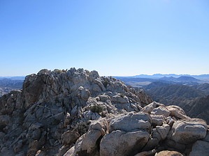
Not the Head by Jim  Most who know of the Cabeza Mountains know of Cabeza Head, the black-capped mountain further south which is sometimes visible from El Camino Del Diablo. Cabeza Head is not the high point of the range, however. Cabeza Benchmark at 2,830' is! Most who know of the Cabeza Mountains know of Cabeza Head, the black-capped mountain further south which is sometimes visible from El Camino Del Diablo. Cabeza Head is not the high point of the range, however. Cabeza Benchmark at 2,830' is!Isolation and quiet are almost guaranteed here. Unlike other busy parts of the Barry Goldwater and Cabeza Prieta, you're away from most activity as this part of the refuge and range is accessed by a spur road, not the main cross refuge road of El Camino Del Diablo. You may see no one at all, or mostly see Border Patrol Activity. Military training on the ground most likely won't get into this area, either. There is potential for illegal border crossing activity.
The next section will last for several miles. Primarily, you will walk the wash bottom, but at times it may be helpful to leave the wash and cross low ridges and benches. Study the terrain on the south side of the canyon. A steep rock face will begin to have some deep canyons in it. The next step is to enter the correct canyon to begin your scramble up to the summit. After 3 to 4 miles of canyon bottom, ahead you may notice the normally wide canyon narrows together at a point perhaps 500 feet wide. Roughly 1/2 mile before this, a canyon appears on the right and is visible due south of the wash or canyon bottom. Head towards this south trending canyon and notice that from the mouth of this side canyon there is a second deeper canyon that leaves from the same canyon mouth and runs to the southwest. I called this the bifurcate canyon, as it appears to be on the topographic map I used. The second southwest trending canyon is noticeably deeper than the south trending one. Scramble up the deep southwest trending canyon as it begins to curve towards the south. It will steepen and narrow forcing you to a small saddle. From the saddle, you can look south and may be able to see the Sea of Cortez, and another range high point, Tinajas Altas High Point. At this point turn east (left) and scramble up the class 2 rock to the summit. Enjoy the view and descend the way you came. Check out the Official Route and Triplogs. Leave No Trace and +Add a Triplog after your hike to support this local community. | ||||||||||||||||||||||||||||||||||||||||||||||||||||||||||||||||||||||||||||||||||||||||||||||||