History: Burney Falls lies at the southeast corner of the Cascade mountains between the Mt Shasta and Mt Lassen volcanoes. The are was occupied by several Indian tribes belonging to the Pit River Nation, named such because they dug huge pits to trap, catch and kill large game. Conflict of course occurred with the arrival of Anglos. Burney Falls and Burney Creek were named after a drifter from South Carolina who arrived in the area in 1858. He was working as a caretaker for a rancher in the area who was known for abusing Indians. The Indians lashed back and Burney was killed. In 1860 The McArthur family arrived and homesteaded the area. In 1917, Pacific Gas and Electric started acquiring a lot of land in the area and the McArthur family along with others became concerned they would destroy the area with the construction of a hydroelectric facility. The McArthur family bought up the property around the falls and deeded it to the California Department of Forestry asking only that the park be named as it is.
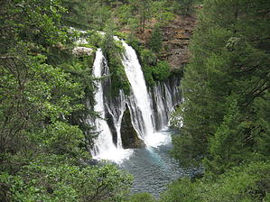
Geology: Burney Falls is a rare combination of springs emanating from an ancient lava flow, meeting Burney Creek, which flows over a later, secondary lava flow called Burney Basalt the secondary lava flow occurred at a much later time in history and is fed above ground by Headwaters Spring. It is clear to see when looking at the falls as Burney creek cascades 129 feet, about half way down the falls, the basalt makeup totally changes and from this point where the two lava flows meet water flows out from the rock face. The two flows of water join to complete the journey into the pool at the base which is 19-24 feet deep. This creates an undercut of the rock face. This process has been going on for millions of years and the falls are believed to once have been three miles downstream, the rock face eroding at a rate of 1/10 inch a year. The water is a constant 42 degrees and because both flows are spring fed, the flow is consistent year round with about 100 million gallons a day flowing over the falls.
Hike: This hike starts with the candy first. The trailhead is a scenic overlook of Burney Falls. Taking this loop in a counterclockwise direction the trail takes several switchbacks on its descent to the base of the falls. A morning trek will leave you with terrible photo light, shooting into the morning light. Mid day or afternoon the light is more accommodating. Some people wade in but the water is very cold. The mist feels good on a summer day. Taking the creek side trail west, downstream the basalt banks on either side of the creek hold secrets informing geologists how these falls have moved along the stream with forces eroding these two separate lava flows. About a quarter mile downstream a wooden bridge crosses Burney Creek then starts up the cliff side on the opposite bank. it's a steep but enjoyable hike in heavy tree cover making it comfortable even on a summer day. Arriving at the top of the falls there are guard rails to prevent anyone getting too close to the edge. The trail continues upstream of the falls to where it meets the Pacific Crest Trail. Continue another quarter mile to another bridge crossing back over to the north side of Burney Creek. The trail then leads back to the trailhead.
WARNING! Hiking and outdoor related sports can be dangerous. Be responsible and prepare for the trip. Study the area you are entering and plan accordingly. Dress for the current and unexpected weather changes. Take plenty of water. Never go alone. Make an itinerary with your plan(s), route(s), destination(s) and expected return time. Give your itinerary to trusted family and/or friends.
Permit $$
Information is listed below
Directions
Road
Paved - Car Okay
To hike Along Hwy 89, at McArthur Burney Falls Memorial State Park, near Burney, Ca. From Hwy #299 junction 5 miles east of Burney, turn north on Hwy #89 and drive 5.9 miles to park entrance. There is a $7.00 day use fee.
 Route Editor