Route Editor

| Guide | ♦ | 8 Triplogs | 0 Topics |
details | drive | no permit | forecast | route |
stats |
photos | triplogs | topics | location |
| 18 | 8 | 0 |
Great Bang for Your Buck! by kingsnake  Hiking from US-93 to Kaiser Hot Spring is easier than hiking in the Phoenix Mountains Preserve. Seriously, anyone without a zimmer frame could do it. Hiking from US-93 to Kaiser Hot Spring is easier than hiking in the Phoenix Mountains Preserve. Seriously, anyone without a zimmer frame could do it.From the trailhead, pass through the gate and under US-93. There is a trail down to the wash. It's a bit slippery, but only 30 ft. and not bad. Once in the wash, follow it west.
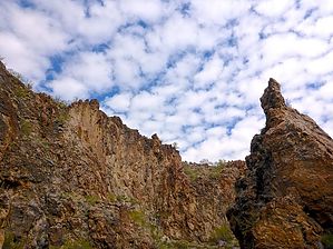
FR 7519 connects to the wash at 1.0 miles. If you want 3.8 extra miles, and a little more AEG, do a loop up FR 7519. (Technically not a forest road, as this is BLM land.) There are some awesome views from up on that unnamed mesa. The route has been sandy to this point but is generally hard pack dirt the remainder of the way to Kaiser Hot Spring. Also, the canyon past FR 7519 is SPECTACULAR. Seriously, take your time: Look backward, up & around. It will blow you away. There are also lots of caves to explore, some without too much climbing. The hot spring itself is warm, not hot, and fed by a hole in the rock that was gushing water when I was there. The overflow trickles down the canyon another ¼ mile to Burro Creek. Past the hot spring, there are "No Trespassing" signs for what appears to be a current mining operation. (Though no one was present when I visited.) Kaiser Hot Spring itself is not large, but it is safe & soft to walk in without shoes. It is calf-deep, so you can sit in it & soak, but not swim. Gate Policy: If a gate is closed upon arrival, leave it closed after you go through. If it is open, leave it open. Leaving a closed gate open may put cattle in danger. Closing an open gate may cut them off from water. Please be respectful, leave gates as found. The exception is signage on the gate directing you otherwise. Check out the Official Route and Triplogs. Leave No Trace and +Add a Triplog after your hike to support this local community. | |||||||||||||||||||||||||||||||||||||||||||||||||||||||||||||||||||||||||||||||||