Lots of ooh-eee-ooh-ah-ah, but no ting-tang-walla-walla-bing-bang by DixieFlyer
Overview
This short spur trail in the Fountain Hills McDowell Mountain Preserve(FHP) leads to the signed West-View Overlook.
Hike
This spur trail to the West-View Overlook runs off of the apex of the Western Trail. This spur trail is marked with a sign saying "West-View Overlook". While this spur trail is short and sweet, the climb up to the trail on the Western Loop Trail is steep and will give almost anyone a good workout. Topo maps mark the overlook with an elevation of 3,098 feet.
There are several large boulders at the summit, which provide good places to sit while you enjoy the views at the summit. Even though this peak is called the West-View Overlook, the best views are off to the east.
Interesting Factoid
The West-View Overlook is located near the east end of a ridgeline that goes up to Peak 3804, which is in the Scottsdale McDowell Sonoran Preserve. The highpoint of the town of Fountain Hills is along this ridgeline at the boundary line of the Fountain Hills and Scottsdale preserves, likely at an elevation of around 3,180 feet.
When hiking several trails on a single "hike", log it with a generic name that describes the hike. Then link the trails traveled, check out the example.
WARNING! Hiking and outdoor related sports can be dangerous. Be responsible and prepare for the trip. Study the area you are entering and plan accordingly. Dress for the current and unexpected weather changes. Take plenty of water. Never go alone. Make an itinerary with your plan(s), route(s), destination(s) and expected return time. Give your itinerary to trusted family and/or friends.
Permit $$
None
Directions
Road
Paved - Car Okay
To Adero Canyon Trailhead From Loop 101 and Shea Blvd head east on Shea Blvd for 7.8 miles. Then turn left on N Palisades Blvd and continue 1.1 miles. Turn left at the stop sign onto Eagle Ridge Drive and continue 2.4 miles until you reach the Adero Canyon Trailhead. Note that along the way Eagle Ridge Drive first becomes N 143rd Way and then becomes N Eagle Ridge Drive.
• February 2019: There is road construction on Eagle Ridge Dr, and the last mile to the trailhead is on a well-graded, unpaved road. However, that section of the road will ultimately be paved.
• January 2020 FHP writes: Fountain Hills (Parks & Wildlife Dept..480-816-5100): Adero Cyn TH/Parking is presently "only" accessible for parking access at the closed chain link fence ~1 mile "prior-to" TH Parking on N. Eagle Ridge Drive. M-F Trailhead access from ~1 mile up road is only legal from 3pm daily. Sat & Sun TH access from ~1 mile up road is legal from dawn to dusk.
• 2020-02-15 Yoder writes: Road to trailhead parking is closed due to construction. You may want to go to the Sunrise Trailhead parking. • 2020-11-09 Grasshopper writes: Officially opened, and the road to the Parking / TH is now paved.
From PHX (I-10 & AZ-51) 43 min (32.3 miles) From TUC (Jct 1-10 & Grant) 2 h 7 min (131 miles) From FLG (Jct I-17 & I-40) 2 h 28 min (155 miles)
 Route Editor

 Overview
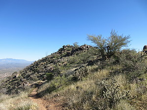


