Route Editor

| Guide | ♦ | 1 Triplog | 0 Topics |
details | drive | permit | forecast | route |
stats |
photos | triplog | topics | location |
| 17 | 1 | 0 |
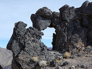
Unsung but Fantastic by rvcarter Corkscrew Peak is located in the Grapevine Mountains about 23 miles NNW of Furnace Creek in Death Valley National Park. The destination reached by this hike/climb affords some of the best 360 degree views in the area. From the top, you can see mountains in Nevada a mere four miles to the NE, Thimble Peak (which is 500 feet higher) to the NNW, and nearly the entire Death Valley salt flats down-valley to the west and south. Note that this hike should be scheduled for the cooler seasons of the year, since trailhead temperatures routinely reach 110 degree Fahrenheit during the summer. There is a nice arch about 650 feet from the top, which makes for a great photo op. Hike/Climb One reason for posting this description is that the information provided at the Park Visitor Center is incorrect (see photos for a copy of their handout). Their rudimentary map, which has no grid or distance scale for navigation, shows two confusing routes, one of which (the west-most route) involves what appears to be some pretty difficult class 3 climbing and a much more difficult route finding exercise. The park’s web site does not provide a gpx track. The worst error is the loop shown around to the north near the top (presumably for a peak approach from the NE ridge) which I would not recommend because of the difficult climbing on the north side. Take this route only if you are up for some adventure and what appears to be class 4 climbing. The use trail clearly follows the best route to reach the top is up a notch on the SE side of the peak. This route, my posted track, is not well signed but is easy to follow and involves only mild class 2 climbing. Print a map showing my track or load my track on your device.
The trail is occasionally (especially near the top) very steep and slippery due to loose rock and soil over the last several hundred feet near the top, but is manageable for most fit hikers with good footwear. We didn't see anyone else on what was a magnificent day for hiking. This hike flies under the radar for Death Valley NP. This is a real winner, but only for cooler seasons of the year. Note There are two trailheads to start the hike (we used the upper one) but the trails converge a few hundred yards in. The upper one, about 0.9 miles NE of the Hells Gate intersection, is at 2700 feet, 11S 502845 E, 4065917 N. The lower one is at 2565 feet, 11S 502494 E, 4065423 N. Check out the Official Route and Triplog. Note This is a moderately difficult hike. Leave No Trace and +Add a Triplog after your hike to support this local community. | |||||||||||||||||||||||||||||||||||||||||||||||||||||||||||||||||||||||||||||||||||||