username
X
password
register
for free!
help


Deer Tanks Trail, AZ

Guide 21 Triplogs  0 Topics
  2.8 of 5  
Fav
Wish
1
details
drive
no permit
forecast
route  
stats
photos
triplogs
topics
location
151 21 0
Statistics
tap row or icons for details
Difficulty 2 of 5
Route Finding 1 of 5
Distance One Way 1.6 miles
Trailhead Elevation 2,056 feet
Elevation Gain 116 feet
Accumulated Gain 151 feet
Avg Time One Way 1 hour
Kokopelli Seeds 2.1
 Interest Off-Trail Hiking & Seasonal Creek
 Backpack Possible - Not Popular
unreported if dogs are allowed
editedit > ops > dogs to adjust
feature photo
Photos Viewed All MineFollowing
Will recalculate on button tap!
14  2025-03-09 DarthStiller
18  2025-01-31
Willow Springs Canyon Upper
Tortoise_Hiker
10  2025-01-31
Willow Springs Canyon Upper
wallyfrack
17  2025-01-28 wallyfrack
8  2025-01-25 wallyfrack
8  2025-01-17 Tortoise_Hiker
6  2025-01-17 wallyfrack
2  2025-01-11
Dome Mountain 3381 - Goldfield Mtns
pseudalpine
Page 1,  2,  3
Author
author avatar Guides 187
Routes 989
Photos 12,068
Trips 864 map ( 6,882 miles )
Age 72 Male Gender
Location Tucson, Arizona
Associated Areas
list map done
Phoenix Region
Historical Weather
Trailhead Forecast
Radar Map
Expand Map
Preferred Jan, Dec, Feb, Nov
Seasons   Late Autumn to Early Spring
Sun  6:03am - 6:46pm
Official Route & 2 Rts
 
6 Alternative


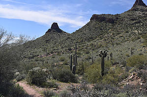
gateway to the Mask/Cyclops
by markthurman53

 
Overview
The Deer Tanks Trail starts at the end of Idaho Road and heads to Deer Tanks, located along Bulldog Canyon. This is a well-maintained trail that heads up to Idaho Saddle, a low lying saddle before heading down to Bulldog Canyon. This is a good trail to take to access Bulldog canyon west, and to what used to be called the Mask Arch, I guess now called the Cyclops since one of the arches collapsed. Deer Tanks where this trail ends are a series of pools in Bulldog canyon. These tanks have had water in them every time I visited them but not sure in the early summer months. Then who would be out here in early summer?


Description
This trail starts at the end of Idaho Road at the Idaho Road Trailhead Parking. The trail heads northwest toward an area called the Spires, an area with many rock formations, including Coyote Rock. The Superstitions can be seen off in the distance to the east. Almost immediately, a trail heads off to the east called the Wolverine Pass Trail and heads over to the Bulldog Canyon Trailhead. The Deer Tanks Trail continues at first to the west, then to the north toward Idaho Saddle, following along a south-flowing wash for a bit. Once at the saddle, the trail follows along a wash that now drains to the north toward Bulldog Canyon. Off to the west and northwest is Bulldog Ridge. There is a large catchment to the west of the trail to catch water just before coming to FR 10, Bulldog Canyon Road, which is about 1.2 miles in.
remove free decal offer
The trail from FR 10 to Bulldog Canyon follows a wash the rest of the way to Deer Tanks. Just before coming to Bulldog Canyon, the trail exits steeply to the east and west, stay in the wash to Deer Tanks in Bulldog Canyon. This east west trail is part of the Bulldog Canyon Trail. If you are heading to the arch called the Mask, you can exit to the east on this trail. This route will take you more directly to the mask and bypass Deer Tanks. The Deer Tanks Trail skirts along the west side of hill 2300. If at the FR 10 Crossing you take FR 10 east, there is a trail that heads north from FR 10 that skirts hill 2300 on the east. Either trail is a good route to take to the arch called the Mask, possibly one in and the other return for a slight change of scenery.

2020-03-09 markthurman53


    Check out the Official Route and Triplogs.
    Leave No Trace and +Add a Triplog after your hike to support this local community.

    One-Way Notice
    This hike is listed as One-Way.

    When hiking several trails on a single "hike", log it with a generic name that describes the hike. Then link the trails traveled, check out the example.
    WARNING! Hiking and outdoor related sports can be dangerous. Be responsible and prepare for the trip. Study the area you are entering and plan accordingly. Dress for the current and unexpected weather changes. Take plenty of water. Never go alone. Make an itinerary with your plan(s), route(s), destination(s) and expected return time. Give your itinerary to trusted family and/or friends.

     Permit $$
    None


     Directions
    or
     Road
    Paved - Car Okay

    To hike
    Idaho Road to its northern terminus at McDowell Road. Trailhead parking to the east of the road.
    page created by markthurman53 on Mar 09 2020 9:19 am
     90+° 8am - 6pm kills
    helpcorrectionissue

    end of page marker