Overview
The “Horse With No Name Trail” is an easy to follow trail that starts along Cottonwood Wash and ends about 1 mile downstream in cottonwood Wash. This trail, I think, is one of the more scenic trails in the Goldfield Mountains. The trail passes by light-colored Rhyolite cliffs, overpasses where the only rock is the Rhyolite, and the trail is a white ribbon bounded by the yellow lichen. Further in, the light Rhyolite gives way to the dark volcanic rock that gives some areas a moonscape appearance. The last stretch of trail is along an unnamed wash with impressive views of the surrounding rugged hills. The saguaro forests along this final section are quite remarkable. This trail should be called the “Horse Trail with No Destination” because it looks like the ones who made the trail went up the canyon to a random place and said that is enough and then returned to Cottonwood Wash via a slightly different route. They did pick a scenic route, though.
Description
This description is in a counterclockwise direction from the southernmost end of the trail along Cottonwood creek. The trail is easy to spot along a small section of road FR 3512, which parallels along Cottonwood wash at this point. The trail appears to be heavily used with lots of signs that it is a typical horse trail. Immediately the trail heads toward some rather tall cliffs of Rhyolite with numerous interesting nooks and crannies. It remains along the lower part of these cliffs, climbing slowly up to a ridge to the south. It gets fascinating from here, at least different from any other trails I have been on in the Goldfields. The trail follows along the top of this pile of Rhyolite, climbing moderately. The trail looks like a white ribbon in a sea of yellow lichen, so you can’t miss the trail. This is a wide-open area, so the views are pretty good, not so much in the distance but the immediate surrounding area. The trail continues west along this rock, slowly dropping into Orohai Wash. The Rhyolite cliffs to the north of the trail start getting taller again. Once past Orohai Wash, the trail ascends a low ridge and crosses another small unnamed wash. The ridge between these two washes is the ridge that ascends the three lesser peaks route to the south. Once past the second wash, the cliffs to the right of the trail (north) are not as tall and made up of jagged dark volcanic rock.
The trail continues alongside this ridge to an unnamed wash. This wash runs parallel to the trail we just came up but on the north side of the ridge of Rhyolite and volcanic rock. Eventually, this wash will run into the Cottonwood Wash. Where this trail comes to the unnamed wash, the trail splits. The more obvious trail heads down the wash but don’t take that. Take the trail that heads upstream. This trail doesn’t go very far, 0.4 miles, upstream before making a loop and heading back downstream, but the landscape along this section is quite impressive. The jagged volcanic rocks give this the moonscape appearance, at least what I would think it would appear. This section of trail adds about 1 mile to the hike, lovely scenery on the return down the unnamed wash to the Cottonwood Wash. There is a magnificent saguaro forest along this section of the wash. Before getting to Cottonwood Wash, Orohai Wash enters from the south. This wash looks easy to navigate and can be used as part of the Three Lesser Peaks route. Once down in the Cottonwood Wash, it can be taken upstream back to the start point.
When hiking several trails on a single "hike", log it with a generic name that describes the hike. Then link the trails traveled, check out the example.
WARNING! Hiking and outdoor related sports can be dangerous. Be responsible and prepare for the trip. Study the area you are entering and plan accordingly. Dress for the current and unexpected weather changes. Take plenty of water. Never go alone. Make an itinerary with your plan(s), route(s), destination(s) and expected return time. Give your itinerary to trusted family and/or friends.
Permit $$
None
Directions
Road
Paved - Car Okay
To hike Cottonwood Trailhead 1.2 miles past the Lost Dutchman State Park on the north side of AZ 88. Park at the trailhead and walk FR 1356 to Cottonwood wash. Take Cottonwood Wash or Frankie Goes to Hollywood Trail to Horse With No Name Trail. If you have a Bull Dog Canyon OHV pass and 4WD you can drive to Cottonwood Wash on FR 1356.
From Hackamore Trailhead. Take the pack saddle trail to Cottonwood Wash at FR 1356
page created by markthurman53 on Mar 09 2020 9:38 am
 Route Editor

 Overview
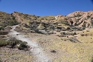


