 Route Editor

| Guide | ♦ | 13 Triplogs | 0 Topics |
details | drive | no permit | forecast | route |
stats |
photos | triplogs | topics | location |
| 74 | 13 | 0 |
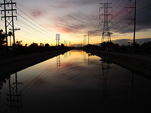
Canals through residential areas of Mesa, Gilbert and Tempe by DarthStiller  The north end of this segment of the Maricopa Trail officially begins at the Park of the Canals in Mesa, off of Horne Road. The MT is designated on the north/west side of the canal, as it bends towards the south. The north side of the canal at first is still open, with views across the valley, and the south side has modest residential homes. As the canal bends to the south, the residential area becomes denser, with many apartment complexes directly adjacent to the canal. This is the South Canal, and it continues until it meets with the Consolidated Canal, only about 0.6 miles in. The north end of this segment of the Maricopa Trail officially begins at the Park of the Canals in Mesa, off of Horne Road. The MT is designated on the north/west side of the canal, as it bends towards the south. The north side of the canal at first is still open, with views across the valley, and the south side has modest residential homes. As the canal bends to the south, the residential area becomes denser, with many apartment complexes directly adjacent to the canal. This is the South Canal, and it continues until it meets with the Consolidated Canal, only about 0.6 miles in.Make a hard left onto the Consolidated Canal, following the MT and Sun Circle Trail signs. The designated trail is now on the north side of the canal, but this will turn into the east side of the canal as this canal now also bends to the south. The surrounding areas are again very dense residential, and very close to the canal, making for a very crowded feel. Several road crossings are encountered, all of which have traffic control signals to give the hiker or biker a chance to stop traffic before they cross.
After crossing under Route 60, there are a few more open residential areas, alternating with some larger yards that appear to have farming and agriculture-related equipment and buildings. Continue to follow the canal on the east side. The crossing of Lindsay Road gets a little confusing, but stay on the east side of the canal, but on the west side of Lindsay. Soon, the trail crosses a bridge onto the east side of the canal. At this point, there is a crossing to get to Freestone Park in Gilbert, which is also another designated trailhead, as well as a junction with the section of the trail that is a 22-mile spur to San Tan Mountain Regional Park. A kiosk with maps of the local area and sections of the trail is also located here to help you. If you continue south to the San Tan section, the trail is on the west side of the canal. If you stay on the East Valley segment, the official designated MT is on the south side of the canal. This canal is the Western Canal and is much smaller than the other canals in the area. It is also primarily dirt lined, without the concrete on other canals. It’s possible to walk on either side of the canal, but the designated MT is on the south side of the canal until Alma School Road, at which point it switches to the north side. The eastern end of this canal is pretty crowded, with dense residential on the south side of the canal. The north side also has residential lots, but they seem to be more open and farm-related. After crossing Gilbert Road on the north end of downtown Gilbert (right next to the new Culinary Dropout restaurant), the surrounding areas open up more. Most of this is industrial. After the crossing with Country Club Road, it’s more residential again, but remains very wide open, with generous setbacks. After passing the Ken McDonald Public Golf Course, the trail follows the Western Canal northbound to Guadalupe Road. At this point, the MT separates from the Western Canal (which continues north) and follows Guadalupe Road westbound into Guadalupe. There is an MT marker on the north side of the road at this turn, but the official MT remains on the south side of the road until just before the crossing of I-10. The last mile before this crossing, there is a dirt path that’s been landscaped. After crossing the bridge over I-10, follow the MT markers and cross the intersection with the South Pointe Parkway. Use caution here as the northwest portion of this does not allow you to walk on a sidewalk and there are very high shrubs around a blind curve. It might be better to cross to the south side sooner for safety’s sake. Continue on the north side of the road and then cross again at the intersection of 48th Street into the entrance for Pima Canyon at South Mountain Park. Follow the trail on the north side of the road into the park until you get to the trailhead, where the MT then turns into the existing trails that are part of that park’s trail system.
Check out the Official Route and Triplogs. Leave No Trace and +Add a Triplog after your hike to support this local community. One-Way Notice This hike is listed as One-Way. When hiking several trails on a single "hike", log it with a generic name that describes the hike. Then link the trails traveled, check out the example. | |||||||||||||||||||||||||||||||||||||||||||||||||||||||||||||||||||||||||||||||||||||||||||||||||||||||||||||||||||||||||||||||||||||||||||||||||||||||||||||||||||||||||


