username
X
password
register
for free!
help
 This is likely a great time to hike this trail!  Check out "Preferred" months below, keep in mind this is an estimate.
 

Subway Cave Loop, CA

Guide 2 Triplogs  0 Topics
  3 of 5  
Fav
Wish
1
details
drive
no permit
forecast
map
stats
photos
triplogs
topics
location
13 2 0
Statistics
tap row or icons for details
Difficulty 1.5 of 5
Route Finding 2 of 5
Distance Lasso-Loop 1 mile
Trailhead Elevation 4,362 feet
Elevation Gain 88 feet
Avg Time Round Trip 2 hours
Kokopelli Seeds 1.44
 Backpack Yes & Connecting
unreported if dogs are allowed
editedit > ops > dogs to adjust
feature photo
Photos Viewed All MineFollowing
9  2017-06-23 LindaAnn
4  2009-07-14 AZLOT69
Author
author avatar Guides 177
Routes 249
Photos 10,213
Trips 2,215 map ( 17,459 miles )
Age 74 Male Gender
Location Gold Canyon, AZ
Associated Areas
list map done
Northern Region
Historical Weather
Trailhead Forecast
Expand Map
Preferred May, Oct, Jun, Sep → 10 AM
Seasons   Late Spring to Early Autumn
Sun  5:36am - 6:32pm
1 Route
 
0 Alternative


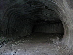
Go prepared! - Caving Checklist
A Cryptid Habitat ?
by AZLOT69

 Likely In-Season!
Geology: Just 20,000 years ago lava flowed into the Hat Creek area. The top crust hardened as the lava continued to flow underground. Eventually the lava flow slowed and drained out of these now formed lava tubes. The shape resembles man made subway tunnels thus the name. Subway cave is the largest accessible cave that has been located in the Hat Creek area.


Legend: The Atsugewi Indians lived in the area. They are also referred to as the Hat Creek Indians and belonged to the larger nation of Pit River Indians. Historians believe their population to have been about 3,000. The Atsugewi avoided the caves as they believed an ape man lived in the caves. This could be an early sighting of Sasquatch.
remove free decal offer
Warning: This is an unescorted trip underground. Make sure you are prepared to Spelunk with proper preparation, equipment and a partner. Visibility underground is zero without a flashlight. Flashlights are available for rent at the Old Station information center just a half mile south of Subway Cave on Highway 89. There are some low ceilings and the cave floor is rough, rocky and unforgiving if you fall. The cave temperature is a constant 46 degrees.

Hike: After a short walk from the trailhead, stairs lead into the cave. After your eyes adjust to the darkness the beauty of the cave starts to reveal itself to your senses. Done in a clockwise direction you enter at the Devils Doorway and proceed down Stubtoe Hall. Around the first bend a test of lights out will amaze at how dark it can be. Proceeding thru the wind tunnel the ceilings will range from 6 feet to 19 feet tall. Hesitating here you can feel a slight breeze. Arriving at a Y, taking a left you will dead end at Lucifers Cul-de-sac. Return to the main cave bear left thru the Sanctum. You then come across a partial collapse which is reassuring. The cave is 1300 feet long but seems much further when traveling it. Stairs at the far end will bring you out into the blinding sunshine and the trail circles around back to the trailhead.

2009-07-17 AZLOT69


    Check out the Triplogs.
    Leave No Trace and +Add a Triplog after your hike to support this local community.
    WARNING! Hiking and outdoor related sports can be dangerous. Be responsible and prepare for the trip. Study the area you are entering and plan accordingly. Dress for the current and unexpected weather changes. Take plenty of water. Never go alone. Make an itinerary with your plan(s), route(s), destination(s) and expected return time. Give your itinerary to trusted family and/or friends.

     Permit $$
    None


     Directions
    or
     Road
    Paved - Car Okay

    To hike
    Subway Cave is located near the town of Old Station,Ca 1/4 mile north of the junction of Highway 44 & 89 across from Cave Campground.
    page created by AZLOT69 on Jul 17 2009 6:30 pm
     90+° 8am - 6pm kills
    helpcorrectionissue

    end of page marker