 Route Editor

| Guide | ♦ | 18 Triplogs | 0 Topics |
details | drive | no permit | forecast | route |
stats |
photos | triplogs | topics | location |
| 78 | 18 | 0 |
Greenbelts and bicycle paths, Scottsdale stuff by DarthStiller  Over half of this segment of the MT, the southern portion, is dedicated as the MT. However, it’s designated segments of sidewalks, walking paths through parks, and a paved bicycle path. This description is from north to south, beginning at the Gateway Trailhead in the Scottsdale McDowell Sonoran Preserve, and ending at Arizona Canal south of Indian Bend Road. Over half of this segment of the MT, the southern portion, is dedicated as the MT. However, it’s designated segments of sidewalks, walking paths through parks, and a paved bicycle path. This description is from north to south, beginning at the Gateway Trailhead in the Scottsdale McDowell Sonoran Preserve, and ending at Arizona Canal south of Indian Bend Road.From the Gateway Trailhead, turn right on the Gateway Loop Trail. After a mile, turn right onto the Paradise Trail and continue south. After 1.5 miles, turn right again onto the Quartz Trail, heading southwest. It’s also possible to park that the Quartz Trail parking lot at 104th St. and McDowell Mountain Ranch Road if you want to skip the majority of this portion of the hike. This lot is not listed as an official trailhead or access point of the MT.
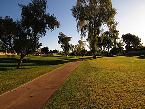
From here is where the “dedicated” portion of this segment of the MT begins. Cross Cactus Road at the Taliesin West entrance, there will be an MT marker there pointing westbound. Cross Frank Lloyd Wright Blvd. and begin walking westbound on the south side of Cactus Road. A dirt path is built on this side of the road, mainly for use by equestrians, but it suits this purpose well as part of the MT. Cactus Road is mainly residential, with a mix of older and newer homes. There are also some training facilities for horses, a counseling facility, and what looks to be an abandoned park. Continue two miles on Cactus Road until it meets the concrete bicycle path just west of 96th Street. At this point, an MT marker can be seen on the north side of Cactus Road, which will direct you to walk into the underpass for the bicycle path. Whether you turn directly left from the south side of Cactus or take the underpass, you will end up on the bicycle path southbound. For a half-mile, the bicycle path follows the east side of 94th Way. After crossing Cholla Street, the bicycle path parallels a drainage channel for almost a mile until it crosses Shea Blvd. There is another underpass at 92nd Street, which begins a series of underpasses that the MT passes through for the next few miles. After Shea Blvd., the trail follows a green belt that begins going through the medical campus, then past some retail shops, under the 101, then past a series of apartment complexes. Near the apartments is a spur to Mountain View Park, which is listed as an official trailhead of the MT. This greenbelt area is very wide, with a lot of room to walk on the grass if you prefer to avoid the concrete walking path. After an underpass of Hayden Road, follow Hayden southbound for just under a half-mile on the west side, then turn right into the park area with Marguerite Lake. This green area has another walking/bicycle path that meanders past two lakes, some golf greens, and more apartments. This greenbelt area doesn’t offer as much room to get away from the concrete path, which can have higher traffic volume from walkers, joggers, and bikers. After the final greenbelt area, turn left onto McCormick Parkway, then right onto Hayden Road again, and head south until you reach the Arizona Canal. From here the MT continues eastbound to the next segment, across the SRPMIC reservation towards Granite Reef. You can also take the Arizona Canal westbound along a segment of the Sun Circle Trail. A retail plaza with several restaurants is located at the southeast corner of Indian Bend and Hayden Roads, which serves well as a trailhead if necessary.
Check out the Official Route and Triplogs. Leave No Trace and +Add a Triplog after your hike to support this local community. One-Way Notice This hike is listed as One-Way. When hiking several trails on a single "hike", log it with a generic name that describes the hike. Then link the trails traveled, check out the example. | |||||||||||||||||||||||||||||||||||||||||||||||||||||||||||||||||||||||||||||||||||||||||||||||||||||||||||||||||||||||||||||||||||||||||||||||||||||||||||||||||||||||||||


