 Route Editor

| Guide | ♦ | 3 Triplogs | 0 Topics |
details | drive | no permit | forecast | route |
stats |
photos | triplogs | topics | location |
| 25 | 3 | 0 |
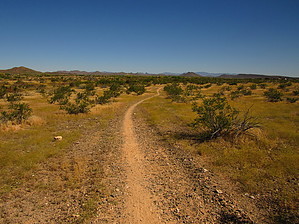
Single track on the edge of development by DarthStiller  This dedicated section of the MT is one of the shortest ones listed on their website, at only 6.1-miles one way, and does not include any sections of existing trails in any local parks. The majority of the path is single track, except for one mile on the east end of the trail that passes by the West Wing substation and around a new subdivision. This dedicated section of the MT is one of the shortest ones listed on their website, at only 6.1-miles one way, and does not include any sections of existing trails in any local parks. The majority of the path is single track, except for one mile on the east end of the trail that passes by the West Wing substation and around a new subdivision.The only designated trailhead for this section of the trail is the Trilby Trailhead, one of the few dedicated trailheads for MT. Trilby TH is also used for the White Tanks/Grand Avenue section of the MT too. This trailhead is very basic, just a gravel lot, about ten parking spaces traced out with river rock, and a kiosk lists the trail's nearby sections.
The north and the West's views are the best, mainly because they have the least views of power lines, highways, and other major infrastructure. Within the first mile, the trail passes by an abandoned building and two wastewater facilities. After that, there is some open space, then (as of April 2020), there is a subdivision under construction, mostly grading. There are signs along the trail indicating detoured sections. However, the actual detours seemed minimal, consisting of extra markers across a graded drainage channel. At the 4.5-mile mark, the trail gets very close to Happy Valley Road, and the traffic is very visible and audible. At just over 5-miles, the trail makes a hard right turn to the south and ends up on a dirt road adjacent to the West Wing substation. It also crosses under the power lines that it had been making some distance with up to this point. After passing the substation, the trail makes a hard left to the north along 179th Avenue, around a newly built subdivision that, as of April 2020, was in the final stages of construction. This segment then officially ends at the oddly shaped intersection of 179th Avenue and Vistancia Boulevard. You can continue eastbound along the south side of Vistancia Blvd., which turns into the Happy Valley Parkway after it passes under the 303 freeway. This is one short section of single track there, which then transitions to a sidewalk. This endpoint is an empty gravel lot, which is also listed as an access point for the trail. It’s possible to cut across this lot without having to strictly look for the official trail markers, just head for the south side of Vistancia.
Check out the Official Route and Triplogs. Leave No Trace and +Add a Triplog after your hike to support this local community. One-Way Notice This hike is listed as One-Way. When hiking several trails on a single "hike", log it with a generic name that describes the hike. Then link the trails traveled, check out the example. | ||||||||||||||||||||||||||||||||||||||||||||||||||||||||||||||||||||||||||||||||||


