 Route Editor

| Guide | ♦ | 6 Triplogs | 0 Topics |
details | drive | no permit | forecast | route |
stats |
photos | triplogs | topics | location |
| 51 | 6 | 0 |
It's exercise... by kingsnake  From the Agua Fria TH, head east further along the paved road. In 150 yds., after crossing over the bridge, turn right onto the decent gravel road. In ¼ mile, pass under the Carefree Hwy. Just past the bridge, split left onto a rougher road, and in 100 yds. turn left onto the single track. All these turns are marked by Maricopa Trail logo signs. From the Agua Fria TH, head east further along the paved road. In 150 yds., after crossing over the bridge, turn right onto the decent gravel road. In ¼ mile, pass under the Carefree Hwy. Just past the bridge, split left onto a rougher road, and in 100 yds. turn left onto the single track. All these turns are marked by Maricopa Trail logo signs.The single track twists uphill, 100 ft. in ¼ mile. Like most of the next four miles, it is quite rocky. Okay for hiking, but too slippery for biking. At the top of the rise, the single track passes through a small cholla forest, then turns south, paralleling the Waddell Canal.
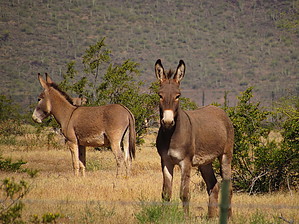
The Maricopa Trail passes under multiple high-tension powerlines. At the three-mile mark, the Maricopa Trail crosses a paved road. To the left, on the east side of Waddell Canal, is Pleasant Valley Airport. Downslope, to the right is Canyon Speedway. If you don't see actual burros, you will see their droppings. After crossing the paved road, the Maricopa Trail gets less rocky the next mile to where Waddell Canal merges with the Central Arizona Project. Immediately after the CAP Canal, turn left on the service road towards Lake Pleasant Pkwy. At Lake Pleasant Pkwy., the Maricopa Trail turns right along a single-track just a few yards from the road. If you’ve developed a flat, you can get a pickup at any of the several pullouts in the ½ mile between the CAP Canal and the Loop 303. (Take the sidewalk across.) On the south side of the Loop 303, the Maricopa Trail becomes a wide, packed, sand path for the next 2½ miles. A mile south of the freeway, on the left side of Lake Pleasant Pkwy., is the entrance drive to Paloma Park. (With water and toilets.) Not quite a half-mile past Paloma Park, on the Maricopa Trail side of the road, is a shady cabana. After 7½ miles, the Maricopa Trail enters civilization (houses, businesses, etc.). ⅓ mile south of Westwing Pkwy., the trail surface changes from hardpack to cement sidewalk. At 8½ miles, turn right on Jomax Rd. In ¾ mile, the road bends left, dropping quickly. At the bottom of the hill, curve right. At the edge of the housing area, turn left across the quarry access road. The next ¾ of a mile to Pleasant Valley Pkwy. you have a choice of adjacent blacktop or hardpack paths. There are nice houses to the left, and the Agua Fria River bottom to the right. After passing under the bridge, the Maricopa Trail turns right, a ½ mile across the (probably dry) Agua Fria River. On the west side of the river, head right, off the jeep trail, up to the sidewalk. Traffic is heavy the next ¾ of a mile to the Loop 303 Freeway (again), so take care at the traffic lights and on/off ramps. On the west side of the Loop 303 Freeway, the sidewalk ends. Head slightly up & left, onto dirt, for the final ¼ mile to 119th Ave. The “trailhead” is a vacant lot
Check out the Official Route and Triplogs. Leave No Trace and +Add a Triplog after your hike to support this local community. One-Way Notice This hike is listed as One-Way. When hiking several trails on a single "hike", log it with a generic name that describes the hike. Then link the trails traveled, check out the example. | |||||||||||||||||||||||||||||||||||||||||||||||||||||||||||||||||||||


