Route Editor

| Guide | 0 Triplogs | 0 Topics |
details | drive | no permit | forecast | map |
stats |
photos | triplogs | topics | location |
| 10 | 0 | 0 |
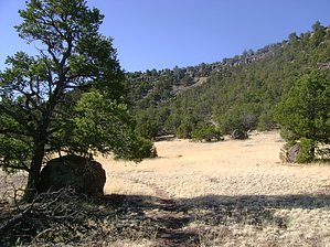
A drive-by hike on the way to Escudilla by azbackpackr   I decided to re-visit the Correjo Crossing Trail along Nutrioso Creek on a cold spring day. I wanted to find some respite from the chilly wind, which had been blowing almost every day throughout the springtime. Since this trail winds along the bottom of a canyon, it is usually somewhat protected from March gales. Although a few patches of snow remained in shady spots, the sun was warm on my face. It was easy to imagine that summer, my favorite season, is just around the corner! I decided to re-visit the Correjo Crossing Trail along Nutrioso Creek on a cold spring day. I wanted to find some respite from the chilly wind, which had been blowing almost every day throughout the springtime. Since this trail winds along the bottom of a canyon, it is usually somewhat protected from March gales. Although a few patches of snow remained in shady spots, the sun was warm on my face. It was easy to imagine that summer, my favorite season, is just around the corner!In years past I had ridden along this trail on a mountain bicycle with some friends of mine, all of them better riders than I ever hope to be! The trail has some rocky, technical sections, which are tough to negotiate unless one is a pretty accomplished mountain biker. I noticed during my hike that the trail has not been maintained at all in recent years. This is too bad because at one time it was designated as a foot and bicycle trail by the Forest Service. Maintenance and new signs are badly needed here.
The trail is fairly easy to follow. It starts as a very rough two-track, but soon branches off to the right and follows the creek, while the two-track goes very steeply up the hill to the left. Take the right fork and soon it becomes a single-track path. In places, if you seem to have lost the trail, look for the small rock cairns placed there by previous hikers and cyclists. Eventually the trail contours up along the side of the hill, away from the creek. At the end of the trail, it's back by the creek again. The trail ends at a barbed wire fence, beyond which is private property. Leave No Trace and +Add a Triplog after your hike to support this local community. | |||||||||||||||||||||||||||||||||||||||||||||||||||||||||||||||||||||||||||||