History: Discovery Point is where the first reported sighting of Crater Lake occurred by an anglo. A gold prospector named John Hillman left his name and date on a crude plaque in 1853. The lake was rediscovered and was given various names over the years but first named Crater Lake in 1869. It was designated as the nations sixth National Park in 1902.
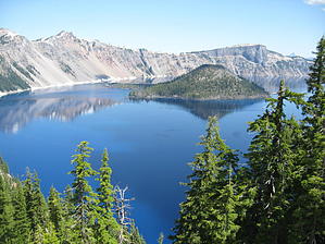
Geology: Crater Lake is the result of a volcano, Mt Mazama collapsing inward about 6,800 years ago. A subsequent eruption created what we now see as an island and sealed the caldera bottom with fresh lava. The island is called Wizard Island. There are no streams, creeks, or rivers that feed Crater Lake and there is no outlet. The heavy annual snowfall melting took 800 years to fill the caldera. The lake has reached a level of equillibrium between its evaporation and the annual remelt of snow. Crater Lake is the deepest freshwater lake in the United States at 1932 feet.
Hike: Starting from the Rim Village, the trail follows the rim westward, paralleling the West Rim Drive. You will encounter many people no doubt on this trail due to the scenic pullouts from the road, which offers nice photographic opportunities of Crater Lake and Wizard Island for the casual tourist. It is a connector trail however for extended dayhikes or backpacking and a side excursion for the Pacific Crest Trail. The rim is about 1,000 feet above the lake and there are no safe ways down to the lake from the south side of the lake. As the continues around the southwest end of the lake it climbs several hills thru stands of trees and rock outcroppings with each vantage point offering a new and unique look at the lake. If you are going to pick only one hike at Crater Lake this would be a good choice.
When hiking several trails on a single "hike", log it with a generic name that describes the hike. Then link the trails traveled, check out the example.
WARNING! Hiking and outdoor related sports can be dangerous. Be responsible and prepare for the trip. Study the area you are entering and plan accordingly. Dress for the current and unexpected weather changes. Take plenty of water. Never go alone. Make an itinerary with your plan(s), route(s), destination(s) and expected return time. Give your itinerary to trusted family and/or friends.
Permit $$
NPS
Directions
Road
Paved - Car Okay
To hike From Klamath Falls - Route 97 north to Route 62 north and west to the park's south entrance. Once in the park continue to the Rim Village for the trailhead.
 Route Editor


