 Route Editor

| Guide | ♦ | 5 Triplogs | 0 Topics |
details | drive | no permit | forecast | 🔥 route |
stats |
photos | triplogs | topics | location |
| 49 | 5 | 0 |
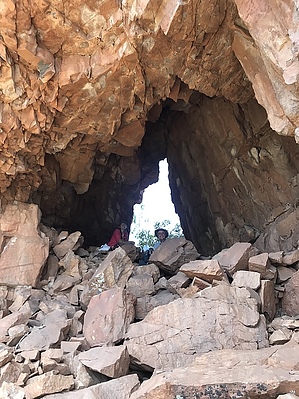
  Warning WarningOff-trail travel is inherently more dangerous than traditional travel along maintained trails. Overview The Devils Window is a worthy off-trail destination in the Sierra Ancha Wilderness that requires moderate off-trail navigation and travel. The approach to the Devils Window begins at the upper Moody Point Trailhead.
The Devils Window was spotted from a distance during a ruin hunting expedition on the south side of Devils Chasm in the fall of 2019. It took seven months before the ruin hunting party was able to confirm that the curious light they saw emitting from a cave in the distance was, in fact, a natural window. Through careful route planning, the window was reached by a party of three on May 10, 2020. The window's location and its appearance of seemingly keeping a watchful eye on the north fork of Devils Chasm and Devils Chasm proper was the inspiration behind the moniker. Hike The hike starts at the Moody Point Trailhead and utilizes the Moody Point Trail #140 for its first leg. The hike to the window is almost entirely downhill from the trailhead and goes quickly until you reach the off-trail portion of the approach. After an approximately 1.5 mile descent of the Moody Point Trail, turn left on the Rim Trail #139 at the signed junction. From here, it is just over a half a mile to the point where you leave the trail. There is a large cairn at the spot where you leave the trail. Make your way along the peninsula-like land feature that divides the two forks of Devils Chasm. Maintain a bit of a rightward angled direction of travel for four-tenths of a mile and then begin a steep descent of the loose gully before you. You do not descend the gully very far before a rock outcropping is visible on the far side. Contour to the rock outcropping and then scramble the steep slope to a flattened area that marks will you begin your traverse of the cliff bands to the Devils Window. The traverse to the window is only a few tenths of a mile. It is a little tedious in spots, but generally pretty moderate for off-trail travel in the Sierra Ancha. There are some faint signs of prehistoric life along the traverse. The ¨cave¨ housing the Devils Window can´t be viewed until clearing the first corner of the traverse. After enjoying a long break in the shady confines of the window and taking in the unique perspective, it offers, return the way you came. Check out the Official Route and Triplogs. Leave No Trace and +Add a Triplog after your hike to support this local community. One-Way Notice This hike is listed as One-Way. When hiking several trails on a single "hike", log it with a generic name that describes the hike. Then link the trails traveled, check out the example. | |||||||||||||||||||||||||||||||||||||||||||||||||||||||||||||||||||||||||||||||||||||||||||||||||||||||||||||||||


